Geologic Atlas of Texas
-
Books & Reports
- Reports of Investigations
- Guidebooks
- Udden Series
- Geological Circulars
- Down To Earth
- Atlases of Major Oil and Gas Reservoirs
- Texas Memorial Museum Publications
- Environmental Geologic Atlas of the Texas Coastal Zone
- Mineral Resource Circulars
- Other Reports
- Seminars and Workshops
- Handbooks
- Submerged Lands of Texas
- Symposia
- Annual Reports
- Open File Reports
-
Maps & Cross Sections
- Thematic Maps
- Miscellaneous Maps, Charts & Sections
- Geologic Atlas of Texas
- STATEMAP Project Maps
- Geologic Quadrangle Maps
- Cross Sections
- Highway Geology Map
- Energy and Mineral Resource Maps
- Shoreline Change and Other Posters
- Wilcox Group, East Texas, Geological / Hydrological Folios
- Bouguer Gravity Atlas of Texas
- River Basin Regional Studies
- Featured Maps
- Posters
- Teachers & the Public
-
Geological Society Publications
- Gulf Coast Association of Geological Societies
- Alabama Geological Society
- Austin Geological Society
- Corpus Christi Geological Society
- Houston Geological Society
- Lafayette Geological Society
- Mississippi Geological Society
- New Orleans Geological Society
- South Texas Geological Society
- GCS SEPM Publications
- Historic BEG & UT Series


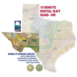
Digital GIS Quadrangle - Northwest Texas. Digital Download
GADQNW-D
Digital GIS Quadrangle - Northwest Texas. Digital Version.
Designed for use with ArcView GIS 3.x and 8.x software products this data covers the Northwest quadrant of Texas showing georeferenced 15-minute GAT (Geologic Atlas of Texas) map Sheet images in .tif format and scanned legend images. It was produced by John Estepp of the Surface Casing Division Texas Commission on Environmental Quality (TCEQ) in March 2004.
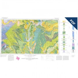
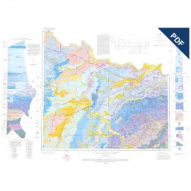
Geologic Atlas of Texas Sheets included in this data are Amarillo, Big Spring, Brownfield, Clovis, Dalhart, Hobbs, Lubbock, Perryton, Plainview, Tucumcari, and Wichita Falls-Lawton.
Citation:
Estepp, John, 2004, Digital GIS Quadrangle - Northwest Texas: The University of Texas at Austin, Bureau of Economic Geology, Digital GIS Quadrangle - Northwest Texas (DQNW).