Geologic Atlas of Texas
-
Books & Reports
- Reports of Investigations
- Guidebooks
- Udden Series
- Geological Circulars
- Down To Earth
- Atlases of Major Oil and Gas Reservoirs
- Texas Memorial Museum Publications
- Environmental Geologic Atlas of the Texas Coastal Zone
- Mineral Resource Circulars
- Other Reports
- Seminars and Workshops
- Handbooks
- Submerged Lands of Texas
- Symposia
- Annual Reports
- Open File Reports
-
Maps & Cross Sections
- Thematic Maps
- Miscellaneous Maps, Charts & Sections
- Geologic Atlas of Texas
- STATEMAP Project Maps
- Geologic Quadrangle Maps
- Cross Sections
- Highway Geology Map
- Energy and Mineral Resource Maps
- Shoreline Change and Other Posters
- Wilcox Group, East Texas, Geological / Hydrological Folios
- Bouguer Gravity Atlas of Texas
- River Basin Regional Studies
- Featured Maps
- Posters
- Teachers & the Public
-
Geological Society Publications
- Gulf Coast Association of Geological Societies
- Alabama Geological Society
- Austin Geological Society
- Corpus Christi Geological Society
- Houston Geological Society
- Lafayette Geological Society
- Mississippi Geological Society
- New Orleans Geological Society
- South Texas Geological Society
- GCS SEPM Publications
- Historic BEG & UT Series


Plainview Sheet. Digital Download
GA0027D
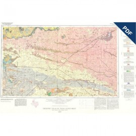
Geologic Atlas of Texas, Plainview Sheet, by G. K. Eifler, Jr., T. F. Hentz, J. C. Frye, A. B. Leonard, and V. E. Barnes. Color map, scale 1:250,000, 1968; revised 1992. For digital GIS files, order: GADQNW-D. Digital Version.
For a print version: GA0027.
Part of the Geologic Atlas of Texas, the Plainview Sheet is an oversize color map that depicts surface geology of Swisher, Briscoe, Hall, and Childress Counties and parts of Randall, Armstrong, Donley, Collingsworth, Hale, Floyd, Motley, and Cottle Counties.
This map was published as a memorial to William Fletcher Cummins, a pioneer in mapping West Texas geology and a specialist in the study of the Permian rocks of West Texas and New Mexico. These rocks are depicted in the eastern two-thirds of the Plainview Sheet.
Citation:
Eifler, G. K., Jr., Hentz, T. F., Frye, J. C., Leonard, A. B., and Barnes, V. E., 1974, Geologic Atlas of Texas, Plainview Sheet: The University of Texas at Austin, Bureau of Economic Geology, Geologic Atlas of Texas, map scale 1:250,000.