Publications in Texas
| Title | Publication Year Sort ascending | Abstract | Author | Series | Publisher | |
|---|---|---|---|---|---|---|
|
The aluminum industry of Texas | 1981 | Barron, Terry | Mineral Resource Circular | Bureau of Economic Geology | |
|
Statistical analysis of lineaments and their relation to fracturing, faulting, and halokinesis in the east Texas basin | 1981 | Lineament analysis is part of a broad spectrum of structural studies employed to determine the tectonic stability of the East Texas Basin. Such information is necessary to assess the suitability of East Texas salt domes as possible repository sites for the storage of high-level nuclear wastes. |
Dix, O.R., Jackson, M.P.A. | Report of Investigations | Bureau of Economic Geology |

|
Geology and geohydrology of the Palo Duro basin, Texas panhandle -- a report on the progress of nuclear waste isolation feasibility studies (1980) | 1981 | Integrated study of the basin structure, tectonic history, physical stratigraphy, hydrogeology, geochemistry, geomorphology, natural resources, and rock physics of the Palo Duro and Dalhart Basins in the Texas Panhandle is part of a national evaluation of ancient salt basins as potential sites fo |
Gustavson, T.C., Bassett, R.L., Finley, R.J., Goldstein, A.G., Handford, C.R., McGowen, J.H., Presley, M.W., Baumgardner, R.W., Jr. | Geological Circular | Bureau of Economic Geology |
|
Catahoula Formation of the Texas coastal plain: origin, geochemical evolution, and characteristics of uranium deposits | 1980 | The Catahoula Formation is composed of ancient fluvial sediments that controlled a wide range of water/sediment interactions responsible for uranium mobilization, transportation, and concentration. |
Galloway, W.E., Kaiser, W.R. | Report of Investigations | Bureau of Economic Geology |
|
The Queen City Formation in the East Texas embayment: a developmental record of riverine, tidal and wave interaction | 1980 | Five distinct facies are recognized in the Eocene Queen City exposures between the Trinity River valley and the Louisiana state boundary. These facies (fluvial, deltaic, tidal flat, barrier, and tidal delta) display diagnostic suites of physical and biogenic structures. |
Hobday, D.K., Morton, R.A., Collins, E.W. | Geological Circular | Bureau of Economic Geology |
|
Lignite resources in Texas | 1980 | Texas lignite occurs in three Eocene (lower Tertiary) geologic units--the Wilcox Group, Jackson Group, and Yegua Formation--and in three ancient depositional systems--fluvial, deltaic, and strandplain/lagoonal. |
Kaiser, W.R., Ayers Jr., W.B., La Brie, L.W. | Report of Investigations | Bureau of Economic Geology |
|
Studies of the suitability of salt domes in east Texas basin for geologic isolation of nuclear wastes | 1980 | The suitability of salt domes in the east Texas basin (Tyler basin), Texas, for long-term isolation of nuclear wastes is being evaluated. The major issues concern hydrogeologic and tectonic stability of the domes and potential natural resources in the basin. |
Kreitler, C.W. | Geological Circular | Bureau of Economic Geology |
|
Modern depositional environments of the Texas coast | 1980 | The Texas Coastal Plain is ideal for studying physical processes and the late Quaternary sedimentological record. |
Morton, R.A., McGowen, J.H. | Guidebook | Bureau of Economic Geology |
|
Distribution and significance of coarse biogenic and clastic deposits on the Texas inner shelf | 1980 | Sediments of the Texas inner shelf are generally fine grained; coarse clasts ( > 0.5 mm) are uncommon (< 1%) over much of the area. Higher concentrations of coarse material, however, occur in discrete areas that apparently represent positions of foyer deltas. |
Morton, R.A., Winker, C.D. | Geological Circular | Bureau of Economic Geology |
|
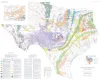
Mineral resources of Texas | 1979 | The Mineral Resources of Texas map is designed to illustrate the historical and current (as of 1976) distribution of industrial mineral occurrences and production sites in Texas. |
Garner, L.E., St. Clair, A.E., Evans, T.J. | Energy and Mineral Resource Maps | Bureau of Economic Geology |