Publications in Texas
| Title | Publication Year Sort ascending | Abstract | Author | Series | Publisher | |
|---|---|---|---|---|---|---|
|
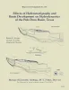
Subsidence and collapse at Texas salt domes | 1988 | Subsidence at salt domes results from man-induced and natural removal of salt, cap rock, minerals within the cap rock, and supradomal fluids. In the Houston diaper province, Frasch sulfur mining as caused subsidence bowls and collapse sinkholes at 12 of the 14 sulfur productive domes. |
Mullican, W.F. | Geological Circular | Bureau of Economic Geology |
|
Hydrogeology and hydrochemistry of Cretaceous aquifers, Texas panhandle and eastern New Mexico | 1988 | Cretaceous rocks in the Southern High Plains, traditionally considered to be part of the High Plains aquifer and recharged by the overlying Ogallala aquifer, actually contain three aquifers with different recharge sources. |
Nativ, Ronit, Gutierrez, G.N. | Geological Circular | Bureau of Economic Geology |
|
Regional structural cross sections, mid-Permian to Quaternary strata, Texas panhandle and eastern New Mexico: distribution of evaporites and areas of evaporite dissolution and collapse | 1988 | The Palo Duro Basin of the Texas Panhandle and eastern New Mexico contains bedded Permian salts of sufficient thickness and depth for the basin to be considered as a potential site for long-term storage and isolation of high-level nuclear waste. |
McGookey, D.A., Gustavson, T.C., Hoadley, A.D. | Cross Sections | Bureau of Economic Geology |
|
Morphometric studies of subhumid and semiarid drainage basins, Texas panhandle and northeastern New Mexico | 1987 | Data from five drainage basins in the Texas Panhandle and northeastern New Mexico characterize the recent history of regional drainage basin formation and landscape development around the margins of the Southern High Plains. |
Baumgardner, R.W., Jr., Mawhorter, J.F., Moustafa, A.R., Myers, R.M., Sandstrom, M.A. | Report of Investigations | Bureau of Economic Geology |
|
Effects of hydrostratigraphy and basin development on hydrodynamics of the Palo Duro Basin, Texas | 1987 | Deep brine aquifers of the Palo Duro Basin, Texas Panhandle, ranging in depth from about 1,000 to 3,000 m below land surface, are underpressured compared with the shallow Ogallala aquifer. |
Senger, R.K., Fogg, G.E., Kreitler, C.W. | Report of Investigations | Bureau of Economic Geology |
|
Origin and evolution of deep-basin brines, Palo Duro basin, Texas | 1987 | Porous and permeable strata of the Deep-Basin Brine aquifer underlie bedded evaporites that are being considered as repositories for high-level nuclear waste isolation in the Palo Duro Basin, Texas Panhandle. Formation-water samples collected from four U.S. |
Fisher, R.S., Kreitler, C.W. | Report of Investigations | Bureau of Economic Geology |

|
Landsat-based lineament analysis, East Texas basin and Sabine uplift area | 1987 | Lineament analysis was used to study the relationship between subsurface structure and surficial features in East Texas, southeastern Oklahoma, southwestern Arkansas, and northwestern Louisiana-areas of low topographic relief, moderate vegetation cover, and diverse land use. |
Baumgardner, R.W., Jr. | Report of Investigations | Bureau of Economic Geology |
|
Controls on porosity and permeability of hydrocarbon reservoirs in Lower Tertiary sandstones along the Texas Gulf Coast | 1986 | Examination of porosity and permeability (reservoir quality) data, as determined by whole core, acoustic log, and petrographic analyses of lower Tertiary sandstones along the Texas Gulf Coast, made it possible to delineate areas most favorable for development of hydrocarbon reservoirs. |
Loucks, R.G., Dodge, M.M., Galloway, W.E. | Report of Investigations | Bureau of Economic Geology |
|
Lower Miocene (Fleming) depositional episode of the Texas coastal plain and continental shelf: structural framework, facies, and hydrocarbon resources | 1986 | The Fleming Group and its basinward equivalents constitute the stratigraphic record of one of the major Cenozoic depositional episodes of the northern Gulf Coast Basin. The depositional sequence representing the episode is bounded above by the Amphistegina B shale and below by the Anahuac shale. |
Galloway, W.E., Jirik, L.A., Morton, R.A., DuBar, J.R. | Report of Investigations | Bureau of Economic Geology |
|
Structural styles of the Wilcox and Frio growth-fault trends in Texas: constraints on geopressured reservoirs | 1986 | The wide variability in structural styles within the growth-faulted, geopressured trends of the Texas Gulf Coast is illustrated by detailed structural maps of selected areas of the Wilcox and Frio growth-fault trends and quantified by statistical analysis of fault compartment geometries. |
Ewing, T.E., Anderson, R.G., Babalola, O., Hubby, K., Padilla y Sanchez, R.J., Reed, R.S. | Report of Investigations | Bureau of Economic Geology |