Publications in Jeff Davis
| Title | Publication Year Sort ascending | Abstract | Author | Series | Publisher | |
|---|---|---|---|---|---|---|
|
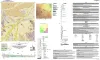
Geologic Map of the Toyahvale Quadrangle, Jeff Davis and Reeves Counties, Texas | 2025 | Hunt, B.B., Helper, M.A., Horne, E.A., Hennings, P.H., Rhoden, E. | Open-File Map | Bureau of Economic Geology | |

|
Regional stratigraphic cross sections, Comanche Cretaceous (Fredericksburg - Washita Division), Edwards and Stockton plateaus, West Texas: interpretation of sedimentary facies, depositional cycles, and tectonics | 2000 | Six interlocking regional stratigraphic cross sections of Lower Cretaceous strata (middle Albian-lower Cenomanian) of the Edwards and Stockton Plateaus of West Texas illustrate the vertical and lateral extent of lithostratigraphic units and distribution of facies and facies tracts. |
Smith, C.I., Brown, J.B., Lozo, F.E. | Cross Sections | Bureau of Economic Geology |
|
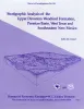
Stratigraphic analysis of the Upper Devonian Woodford Formation, Permian Basin, West Texas and southeastern New Mexico | 1991 | The Upper Devonian Woodford Formation is an organic-rich petroleum source rock that extends throughout West Texas and southeastern New Mexico and currently is generating oil or gas in the subsurface. |
Comer, J.B. | Report of Investigations | Bureau of Economic Geology |
|
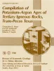
Compilation of potassium-argon ages of Tertiary igneous rocks, Trans-Pecos Texas | 1986 | This compilation of potassium-argon (K-Ar) ages of igneous rocks of the Tertiary volcanic field of Trans-Pecos Texas includes all published ages known to us as well as many unpublished results. |
Henry, C.D., McDowell, F.W., Price, J.G., Smyth, R.C. | Geological Circular | Bureau of Economic Geology |
|
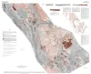
Tectonic map of the Basin and Range Province of Texas and adjacent Mexico | 1985 | Henry, C.D., Price, J.G., Gluck, J.K., Bockoven, N.T. | Miscellaneous Map | Bureau of Economic Geology | |
|
Annotated bibliography of mineral deposits in Trans-Pecos Texas | 1983 | Price, J.G., Henry, C.D., Standen, A.R. | Mineral Resource Circular | Bureau of Economic Geology | |

|
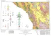
Geologic Atlas of Texas, Fort Stockton sheet (revised 1994) | 1982 | Geologic map that depicts the surface geology of parts of Jeff Davis, Reeves, Pecos, Terrell, Brewster, and Presidio Counties, Texas. The 9-page booklet indicates geologic formations, abbreviations, and ages. |
Barnes, V.E., Humboldt Oil and Refining Co., Mobil Oil Co., Geophoto Services Inc., Cities Service Petroleum Co., Anderson, J.E., Brown, J.B., Gries, J.C. | Geologic Atlas of Texas | Bureau of Economic Geology |
|
Structure of the Presidio Bolson area, Texas, interpreted from gravity data | 1980 | Mraz, J.R., Keller, G.R. | Geological Circular | Bureau of Economic Geology | |
|
Geologic Atlas of Texas, Marfa sheet | 1979 | Geologic map that depicts surface geology of parts of Hudspeth, Culberson, Jeff Davis, and Presidio Counties, Texas. The 12-page explanatory booklet indicates geologic formations, abbreviations, and ages. |
Barnes, V.E., Twiss, P.C., Continental Oil Co., Cities Service Petroleum Co., Geophoto Services Inc., Norman, D.M., Sherrod, C.H., Pearson, B.T. | Geologic Atlas of Texas | Bureau of Economic Geology |
|
Geologic setting and geochemistry of thermal water and geothermal assessment, Trans-Pecos Texas | 1979 | Hot springs and wells in West Texas and adjacent Mexico are manifestations of active convective geothermal systems concentrated in a zone along the Rio Grande between the Quitman Mountains and Big Bend National Park. |
Henry, C.D. | Report of Investigations | Bureau of Economic Geology |