Austin Geological Society
-
Books & Reports
- Reports of Investigations
- Guidebooks
- Udden Series
- Geological Circulars
- Down To Earth
- Atlases of Major Oil and Gas Reservoirs
- Texas Memorial Museum Publications
- Environmental Geologic Atlas of the Texas Coastal Zone
- Mineral Resource Circulars
- Other Reports
- Seminars and Workshops
- Handbooks
- Submerged Lands of Texas
- Symposia
- Annual Reports
- Open File Reports
-
Maps & Cross Sections
- Thematic Maps
- Miscellaneous Maps, Charts & Sections
- Geologic Atlas of Texas
- STATEMAP Project Maps
- Geologic Quadrangle Maps
- Cross Sections
- Highway Geology Map
- Energy and Mineral Resource Maps
- Shoreline Change and Other Posters
- Wilcox Group, East Texas, Geological / Hydrological Folios
- Bouguer Gravity Atlas of Texas
- River Basin Regional Studies
- Featured Maps
- Posters
- Teachers & the Public
-
Geological Society Publications
- Gulf Coast Association of Geological Societies
- Alabama Geological Society
- Austin Geological Society
- Corpus Christi Geological Society
- Houston Geological Society
- Lafayette Geological Society
- Mississippi Geological Society
- New Orleans Geological Society
- South Texas Geological Society
- GCS SEPM Publications
- Historic BEG & UT Series

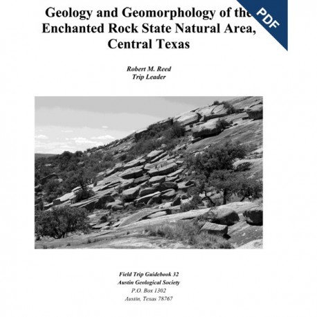
Geology and Geomorphology of Enchanted Rock State Natural Area, Central Texas. Digital Download
AGS GB 32D
For a print version: AGS GB 32.
AGS GB 32D. Geology and Geomorphology of Enchanted Rock State Natural Area, Central Texas. R. M. Reed, Trip Leader. 46 p., 2011. AGS GB 32D, Downloadable PDF.
To purchase this publication in book format, please order AGS GB 32.
From the Preface
Enchanted Rock lies along Ranch-to-Market Road 965 approximately halfway between Fredericksburg and Llano. It is the most prominent of several exfoliation domes and related granite features that crop out in this area. Elevation at its crest is 1825 ft above mean sea level, and it rises about 450 ft above Sandy Creek, which flows along the southeastern margin of the batholith. It is an iconic geologic and geographic feature of Central Texas, and it has inspired awe as long as humans have been here to witness it. The very name, Enchanted Rock, derives from the mysterious (perhaps mystical) properties vested in the feature by the earliest people to visit it. But regardless of its reputation for the mysterious, Enchanted Rock is widely recognized as a magnificent natural feature as well as a historical site. It was designated a National Natural Landmark in 1970 (by the National Park Service), and it was placed on the National Register of Historic Places in 1984. Enchanted Rock State Natural Area was established in 1984 under the aegis of the Texas Parks and Wildlife Department (TP&WD).
Enchanted Rock offers lessons in geology, geography, and ecology. It also poses enigmatic questions that point the way to future investigations. It provides a window into the deep reaches of the Earth’s crust, and it offers clues to the evolution of the North American continent in the deep past. Among the enigmas, there is the question of topography and relief: Why do exfoliation domes stand tall in a few localities? In contrast, across most of the Llano Uplift, the granites generally have been weathered to grus and eroded to low topographic levels adjacent to fault-bound “mountains" of Paleozoic strata. And rimming the Precambrian and Paleozoic outcrops are the high-standing edges of the Edwards Plateau, which once extended unbroken across the Llano Uplift. It is a geologic conundrum: a structural uplift composed of the (presumed) most durable of bedrocks is expressed as a topographic basin.
Keywords: Enchanted Rock, state natural area, Central Texas, Texas, batholith, geomorphology, geology, fieldtrip guidebooks, guidebooks, Austin Geological Society


