Since production of fluorspar began in northern Coahuila, Mexico, in 1950-51, thousands of tons of high-grade ore have been mined from numerous deposits situated 5 to 75 miles south of the Rio Grande. A large part of the fluorspar mined from these deposits has moved northward through Boquillas, Stillwell Crossing, and Heath Crossing to the railhead at Marathon, Texas. Consequently, Marathon has become one of the principal fluorspar shipping points in the world.
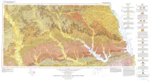
Geologic map that depicts the surface geology of Nacogdoches, Shelby, San Augustine, Sabine, and Angelina Counties and parts of Anderson, Cherokee, Rusk, Newton, Jasper, Tyler, Polk, Trinity, Robertson, Madison, Leon, Freestone, and Panola Counties, Texas. This map was published in honor of Sidney Powers, who was one of the leading geologists of his generation and who was classed by many as the most proficient geologist in the oil industry before his death in 1932.
This history of geology at The University of Texas was prepared for the dedication of the new Geology Building, November 1967. It is a brief history; many details have been omitted. The names of most graduates and some faculty will not be found. The mission was to summarize some important landmarks in Geology at The University of Texas and to describe the personalities and personal relationships that explain many of the decisions that have brought us to the present. I propose a toast to those who have made us what we are.----- Keith Young
The uranium industry, born in boom in the late 1940's and early 1950's, fell upon hard times after about a decade of lusty growth as anticipated private markets failed to develop on schedule and the United States Atomic Energy Commission cut back and stretched out its purchase program. Exploration for uranium in the United States came to a halt. Mills closed down or operated on reduced schedules as contracts expired.
Geologic map that depicts surface geology of Crosby, Dickens, and King Counties and parts of Hale, Floyd, Motley, Cottle, King, Lubbock, Lynn, Garza, Kent, and Stonewall Counties. The Lubbock Sheet honors the late Dr. Halbert Pleasant Bybee, distinguished Texas geologist, professor at The University of Texas at Austin from 1914 to 1925 and 1936 to 1957, and the man who organized, and for many years directed, the University Lands Office in Midland, Texas. Dr.