Annual report for the Bureau of Economic Geology 1966
Based on need for convenient, small-scale cartographic units, the basal Cretaceous rocks in Texas from Red River to Burnet County and on the Callahan Divide are herein divided into three distinctive lithologic sequences.
Limestone is one of the most important nonfuel mineral resources in Texas. Annual production exceeds $30 million; value added in the manufacture of such products as cement and lime amounts to about $100 million annually. Lower Cretaceous limestone is the source of more than 40 percent of the State's total production of limestone and is utilized chiefly as crushed stone (aggregate and constructional stone), sources of raw materials for lime and portland cement, chemical and industrial process stone, agricultural limestone, fluxstone, and dimension stone.
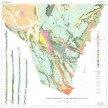
The wedge-shaped Black Gap area in southern Brewsier County, Texas, occupies approximately 4,50 square miles east of the Big Bend National Park. The southwestern boundary of the map area is the castcrn boundary of the Park; the southeastern boundary is the Rio Grande; the north boundary is drawn at lat. 29' 45' N. The area lies in the Trans-Pecos proxince and throughout this arid to semiarid region the climate, flora, and fauna are similar.