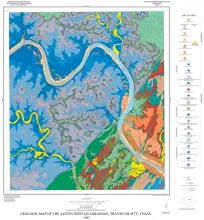
The rocks exposed in the Austin West quadrangle are Cretaceous marine limestones and clays and Quaternary alluvial deposits. The Cretaceous rocks dip gently eastward and are broken by one large (Mount Bonnell) fault and numerous small, northeast-trending faults comprising the Balcones fault zone. Most faults are downthrown to the east; total displacement across the fault zone is about 1,000 feet.
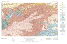
Geologic map that depicts the surface geology of Carson, Gray, and Wheeler Counties and parts of Moore, Hutchinson, Roberts, Hemphill, Potter, Randall, Armstrong, Donley, and Collingsworth Counties.
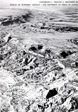
Like the early Spanish explorers who first saw Palo Duro Canyon, today's visitor is likely to view the impressive canyon with surprise and awe. This great depression - it is more than 2 miles wide and as much as 800 feet deep within park boundaries - contains a fascinating assortment of multicolored geologic formations and erosion-produced rock sculptures of many shapes, colors, and sizes. The geographic setting of the canyon further heightens its impact on the visitor, for it is surrounded by the level, virtually treeless plains of the Texas Panhandle.
Upper Pensylvanian and lower Permian rocks of the Eastern Shelf in North-central Texas are composed of 10 to 15 repetitive sequences including open shelf, deltaic, fluvial, and interdeltaic depositional systems. Sediments derived from the Ouachita Mountains and associated piedmont were transported westward across a narrow coastal plain. Fluvial and deltaic sandstone fac1es define a southwest paleoslopc of about 5 feet per mile. Sandstone facies are delta front sheets, distributary mouth bars, distributary and fluvial channels, and destructional bars.