Austin West Quadrangle Publications
| Title | Publication Year Sort ascending | Abstract | Author | Series | Publisher | |
|---|---|---|---|---|---|---|
|
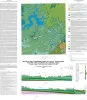
Geologic map of Mansfield Dam, Jollyville, Austin West, and Bee Cave quadrangles, Central Texas (Lower Lake Travis and Lake Austin vicinity) | 2018 | Woodruff, C.M., Jr., Collins, E.W. | Open-File Map | Bureau of Economic Geology | |
|
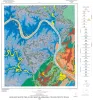
The Guadalupe - Lavaca - San Antonio - Nueces River basins regional study: Seguin West - Austin West sheets | 1985 | Wermund, E.G., Gustavson, T.C., Morton, R.A., Woodruff, C.M., Jr., Macpherson, G.L., McKinney, L., Nilsson, J., Waddell, C.T. | River Basins Regional Studies | Bureau of Economic Geology | |
|
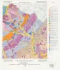
Geologic Map of the Austin West Quadrangle, Travis County, Texas | 1969 | The rocks exposed in the Austin West quadrangle are Cretaceous marine limestones and clays and Quaternary alluvial deposits. |
Rodda, P.U. | Geologic Quadrangle Map | Bureau of Economic Geology |