The purpose of this paper is to present a system of encoding rock data for multiple uses that include (1) mapping subsurface stratigraphy for economic exploration, (2) cataloging borings used in subsurface waste disposal, and (3) building a library of natural resource information. Regional surface and subsurface stratigraphic studies for exploration in sedimentary basins commonly require the handling of numerous columnar sections that display rock descriptions collected from both outcrop and borings.
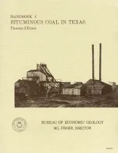
Coal is found in six areas in Texas, including the large North-Central Texas field, a distinctive cannel coalfield in Webb County, and Late Cretaceous-age coals near Eagle Pass. Throughout the state coal occurs in thin beds (rarely more than 3 ft thick) under overburden of varying thickness and degrees of consolidation and is generally high-volatile C bituminous coal.
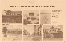
The Texas Coastal Zone is marked by diversity in geography, resources, climate, and industry. It is richly endowed with extensive petroleum reserves, sulfur, and salt, seaports, intracoastal waterways, a mild climate, good water supplies, abundant wildlife, rich agricultural lands, commercial fishing resources, unusual recreational potential, and large tracts of uncrowded land.
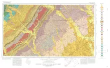
Geologic map that depicts the surface geology of Colorado, Lavaca, and Gonzales Counties, and parts of Hays, Caldwell, Bastrop, Fayette, Austin, Waller, Fort Bend, Wharton, Matagorda, Jackson, Victoria, De Witt, Karnes, Wilson, and Guadalupe Counties, Texas. The 7-page booklet indicates geologic formations, abbreviations, and ages.