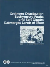
The State-owned submerged lands of Texas encompass nearly 6,000 square miles (15,540 km²) and extend from Mexico to Louisiana. The area includes the bays, estuaries, and lagoons, as well as the inner continental shelf 10.3 miles (16.6 km) seaward of the Gulf shoreline (fig. 1). Many uncertainties exist regarding the future utilization of the State submerged lands, and one cannot anticipate all potential uses for these areas.
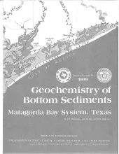
Approximately 800 sediment samples from stream beds and bay bottoms of water bodies that compose the Matagorda Bay system were collected and analyzed. Shell-sand-mud ratios and total organic carbon content were determined, and 20 trace elements were detected. In general, highest concentrations of trace elements coincide with deep areas of- water bodies, areas of mud accumulation, and areas with high total organic carbon content. Zirconium, calcium, strontium, and mercury do not follow the distribution patterns of most other elements.
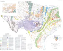
The Mineral Resources of Texas map is designed to illustrate the historical and current (as of 1976) distribution of industrial mineral occurrences and production sites in Texas. Distributions of major rock types used in the mineral industry are also shown, including limestone, dolomite, ceramic clay, nonceramic clay, iron, sand and gravel, trap rock, granite, industrial sand, extrusive igneous rocks, talc, salt, and sulfur. The map also emphasizes the contribution that Texas makes to the National economy, reflecting Texas's position as one of the Nation's leading mineral producers.

Geologic map that depicts the surface geology of parts of Presidio, Brewster, and Terrell Counties, Texas. The 14-page booklet indicates geologic formations, abbreviations, and ages.