
Five distinct facies are recognized in the Eocene Queen City exposures between the Trinity River valley and the Louisiana state boundary. These facies (fluvial, deltaic, tidal flat, barrier, and tidal delta) display diagnostic suites of physical and biogenic structures. Sandstones within these facies exhibit substantial differences in paleocurrent pattern.
In cooperation with several State and Federal agencies, the Bureau of Economic Geology has conducted several projects on the geology, origin, and extent of uranium resources in Texas. This volume, which was prepared in conjunction with a research colloquium sponsored by the Bureau, reviews and synthesizes the results of this research and demonstrates their applicability to the interpretation of uranium deposits.
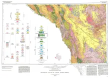
Geologic map that depicts surface geology of parts of Hudspeth, Culberson, Jeff Davis, and Presidio Counties, Texas. The 12-page explanatory booklet indicates geologic formations, abbreviations, and ages.
Potential geopressured geothermal reservoirs in the Vicksburg Formation are limited to Hidalgo County along the Lower Texas Gulf Coast. In Hidalgo County, an area of approximately 385 square miles (designated the Vicksburg Fairway) contains up to 1,300 feet of geopressured sandstones with fluid temperatures greater than 300°F. Inplace effective permeability, however, averages less than 1 millidarcy in the Vicksburg sandstones because of fine grain size and extensive late carbonate cementation.