
Upper Miocene, Pliocene, and Pleistocene deposits in the subsurface of the central Coastal Plain of Texas were subdivided into six operational units comprising the surface-defined Fleming, Goliad, Willis, Lissie, and Beaumont Formations. These sedimentary units constitute the last major depositional episodes in the northwestern Gulf Coast Basin. Late Miocene deposition is represented by transgressive shelf and shallow-marine shales overlain by progradational clastics of the upper part of the Lower Fleming, Upper Fleming, and Lower Goliad-Willis units.
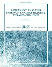
Analysis of seven frames of Landsat imagery covering the Texas Panhandle and adjacent areas revealed linear physiographic features including stream channels, stream valleys, scarps, and aligned playa-lake depressions. These lineaments show preferred orientations of 300°-320°, 030°-050°, and, 0°-020°. The 300°-320° orientation of aligned playas and shallow surface drainage is best developed on the surface of the Southern High Plains. The orthogonal 030°-050° orientation is less well represented.
The Sligo and Hosston Formations of Aptian age occur over thousands of square miles in the subsurface of South Texas. These two formations consist of three major coeval parts, Hosston, lower Sligo, and upper Sligo, all three of which were deposited contemporaneously to produce a time-transgressive wedge of sediment. Superimposed on the overall transgressive sequence are numerous progradational cycles composed of shoaling-upward sequences.
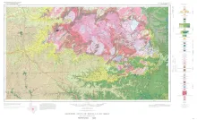
Geologic map that depicts the surface geology of Mason, Llano, and Gillespie Counties and parts of Menard, Kimble, San Saba, McCulloch, Edwards, Real, Kerr, Kendall, Blanco, Hays, Travis, Williamson, and Burnet Counties, Texas. The 15-page booklet indicates geologic formations, abbreviations, and ages.
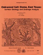
Oakwood Salt Dome in Leon and Freestone Counties, East Texas, is under consideration as a nuclear waste repository. The surficial geology above the dome provides information needed to evaluate the last stages of salt growth in Oakwood Dome and has a bearing on studies of ground-water flow patterns. The Claiborne Group has been uplifted, exposed, and eroded as a result of dome growth. The Carrizo, Reklaw, and Queen City Formations crop out over the dome. The Carrizo Formation comprises bedload- dominated alluvial deposits and is an important aquifer.