
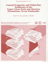
Red beds, evaporites, and carbonates of the upper Clear Fork and Glorieta Formations (Permian) of the Texas Panhandle form an association of facies deposited in nearshore and supratidal environments along an arid coastline. Carbonates were deposited in inner-shelf depositional environments and exhibit upward-shoaling, sabkha-like successions of dolomitic mudstones containing nodular anhydrite. Landward of the shoaling carbonates was a vast salt plain, or sabkha, in which evaporites were deposited in supratidal brine pans and salt flats.
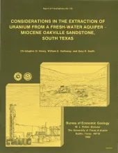
The Miocene Oakville Sandstone is a major aquifer and uranium host beneath the Texas Coastal Plain. In 1976, approximately 6,000 acre-ft of ground water were withdrawn from the Oakville for municipal use. An additional but unknown amount was used for drinking water in rural areas, for livestock, and for irrigation. Potential sustained yield is many times greater. Present and future uranium mining by either surface or in situ methods could affect the availability and quality of Oakville ground water unless the mining is designed properly.
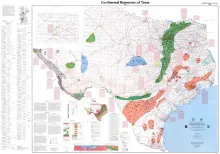
This public-oriented user map shows the generalized extent of geothermal aquifers in Texas. It includes locations and tabular data for selected wells that have representative temperatures and water-quality attributes of the various aquifers.
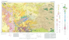
Geologic map that depicts the surface geology of parts of Jeff Davis, Reeves, Pecos, Terrell, Brewster, and Presidio Counties, Texas. The 9-page booklet indicates geologic formations, abbreviations, and ages.
Principal fault systems in the East Texas Basin were examined in terms of their distribution, geometry, displacement history, and possible origins. All the faults studied are normal and moved syndepositionally over approximately 120 Ma (million years); some have listric shapes and associated rollover anticlines. The faults formed by processes associated with gravitationally induced creep of the Louann Salt, such as gliding over a salt decollement zone, crestal extension and collapse over salt pillows and turtle structures, and salt withdrawal from beneath downthrown blocks.