Publication Search

Publications tagged with Gulf Of Mexico

Title Publication Year Sort ascending Abstract Author Series Publisher
Geoenvironmental map of Port Arthur South quadrangle, Texas, Gulf of Mexico Coast Geoenvironmental map of Port Arthur South quadrangle, Texas, Gulf of Mexico Coast 2009 Tremblay, T.A., Caudle, T.L., White, W.A. Open-File Map Bureau of Economic Geology
Geoenvironmental map of Clam Lake quadrangle, Texas, Gulf of Mexico Coast Geoenvironmental map of Clam Lake quadrangle, Texas, Gulf of Mexico Coast 2009 Tremblay, T.A., White, W.A., Caudle, T.L. Open-File Map Bureau of Economic Geology
Geoenvironmental map of Sabine Pass and Texas Point quadrangles, Texas, Gulf of Mexico Coast Geoenvironmental map of Sabine Pass and Texas Point quadrangles, Texas, Gulf of Mexico Coast 2009 Tremblay, T.A., White, W.A., Caudle, T.L. Open-File Map Bureau of Economic Geology
Chronostratigraphy of Cenozoic Depositional Sequences and Systems Tracts: A Wheeler Chart of the Northwest Margin of the Gulf of Mexico Basin Chronostratigraphy of Cenozoic Depositional Sequences and Systems Tracts: A Wheeler Chart of the Northwest Margin of the Gulf of Mexico Basin 2009

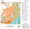
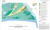
A chronostratigraphic chart (Wheeler chart) was constructed of the Cenozoic strata of the northwest margin of the Gulf of Mexico basin (Texas coastal area).

Brown, L.F., Jr., Loucks, R.G. Report of Investigations Bureau of Economic Geology
Geoenvironmental map of Big Hill Bayou quadrangle, Texas, Gulf of Mexico Coast Geoenvironmental map of Big Hill Bayou quadrangle, Texas, Gulf of Mexico Coast 2009 Tremblay, T.A., Caudle, T.L., White, W.A. Open-File Map Bureau of Economic Geology
Geoenvironmental map of southwest Bolivar Peninsula, Bolivar and Flake quadrangles, Texas Gulf of Mexico Coast Geoenvironmental map of southwest Bolivar Peninsula, Bolivar and Flake quadrangles, Texas Gulf of Mexico Coast 2007 Tremblay, T.A., White, W.A., Waldinger, R.L., Collins, E.W. Open-File Map Bureau of Economic Geology
Reservoir Geology, Structural Architecture, and Sequence Stratigraphy of a Growth-Faulted Subbasin: Oligocene Lower Frio Formation, Red Fish Bay Area, South Texas Gulf Coast Reservoir Geology, Structural Architecture, and Sequence Stratigraphy of a Growth-Faulted Subbasin: Oligocene Lower Frio Formation, Red Fish Bay Area, South Texas Gulf Coast 2007

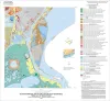
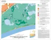
An integrated study using 3D seismic, wireline logs, and core analyses was conducted to establish new strategies for exploring compartmentalized, lowstand, prograding deltaic systems.

Hammes, Ursula, Loucks, R.G., Brown, L.F., Jr., Treviño, R.H., Montoya, Patricia, Remington, R.L. Report of Investigations Bureau of Economic Geology
Geo-Environmental map of Southwest Galveston Island, San Luis Pass and Sea Isle quadrangles, Texas Gulf of Mexico Geo-Environmental map of Southwest Galveston Island, San Luis Pass and Sea Isle quadrangles, Texas Gulf of Mexico 2006 Tremblay, T.A., Gibeaut, J.C., Waldinger, R.L., White, W.A., Collins, E.W. Open-File Map Bureau of Economic Geology
Geo-Environmental map of Northern Mustang Island, Port Aransas quadrangle, Texas Gulf of Mexico Coast Geo-Environmental map of Northern Mustang Island, Port Aransas quadrangle, Texas Gulf of Mexico Coast 2006 Tremblay, T.A., Gibeaut, J.C., Waldinger, R.L., White, W.A., Collins, E.W. Open-File Map Bureau of Economic Geology
Geo-Environmental map of Southern Mustang Island, Crane Islands NW quadrangle, Texas Gulf of Mexico Coast Geo-Environmental map of Southern Mustang Island, Crane Islands NW quadrangle, Texas Gulf of Mexico Coast 2006 Tremblay, T.A., Gibeaut, J.C., Waldinger, R.L., White, W.A., Collins, E.W. Open-File Map Bureau of Economic Geology