|
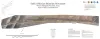
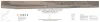
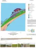
Gulf of Mexico Shoreline Change, Western Matagorda Peninsula, Texas: Pass Cavallo to Colorado River |
2021 |
|
Caudle, T.L., Paine, J.G., Andrews, J.R., Suarez, J.R. |
Posters |
|
|
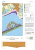
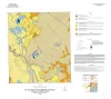
Geologic map of the Frozen Point and Caplen quadrangles, Texas Gulf of Mexico coast |
2021 |
|
Caudle, T.L., Paine, J.G. |
Open-File Map |
Bureau of Economic Geology |
|
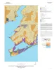
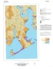
Geologic map of the Palacios and part of the Palacios Point quadrangles, Texas Gulf of Mexico coast |
2021 |
|
Paine, J.G., Costard, L. |
Open-File Map |
Bureau of Economic Geology |

|
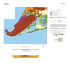
Geologic map of the Turtle Bay quadrangle, Texas Gulf of Mexico coast |
2021 |
|
Paine, J.G., Costard, L. |
Open-File Map |
Bureau of Economic Geology |
|
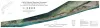
Gulf of Mexico Shoreline Change, Southern Padre Island and Brazos Island, Texas: Rio Grande (U.S./Mexico Border) to Port Mansfield Channel |
2021 |
|
Caudle, T.L., Paine, J.G., Andrews, J.R., Suarez, J.R. |
Posters |
|
|
Gulf of Mexico Shoreline Change, Eastern Matagorda Peninsula, Texas: Colorado River to Brazos River |
2021 |
|
Caudle, T.L., Paine, J.G., Andrews, J.R., Suarez, J.R. |
Posters |
|
|
Geologic map of the Bloomington quadrangle, Texas Gulf of Mexico coast |
2020 |
|
Paine, J.G., Costard, L. |
Open-File Map |
Bureau of Economic Geology |
|
Geologic map of the Olivia and part of the Keller Bay quadrangles, Texas Gulf of Mexico coast |
2020 |
|
Paine, J.G., Costard, L. |
Open-File Map |
Bureau of Economic Geology |
|
Geologic map of the Lake Stephenson and part of the Smith Point quadrangles, Texas Gulf of Mexico coast |
2020 |
|
Caudle, T.L., Paine, J.G. |
Open-File Map |
Bureau of Economic Geology |
|
Geologic map of the Flake quadrangle, Texas Gulf of Mexico coast |
2019 |
|
Caudle, T.L., Paine, J.G. |
Open-File Map |
Bureau of Economic Geology |