|
Depositional systems in the Sparta Formation (Eocene) Gulf coast basin of Texas |
Ricoy, J.U., Brown, L.F., Jr. |
1977 |
Geological Circular |
|
Depositional systems in the Paluxy Formation (Lower Cretaceous), northeast Texas -- oil, gas, and ground water resources |
Caughey, C.A. |
1977 |
Geological Circular |
|
Early Tertiary Vertebrate Faunas, Big Bend Area, Trans-Pecos Texas: Brontotheriidae |
|
1977 |
Texas Memorial Museum |
|
Mineral lands in the city of Dallas |
St. Clair, A.E. |
1977 |
Geological Circular |

|
Ethnic Identities of Extinct Coahuiltecan Populations: Case of the Juanca Indians |
|
1977 |
Texas Memorial Museum |
|
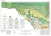
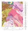
Geologic Atlas of Texas, Del Rio sheet |
Barnes, V.E., Waechter, N.B., Pinkley, G.R., Martin, R.G., Wyeth, J.C., Knupke, J.A., Sulik, J.F., Ellis, W.G., Bowman, G.B., Sams, R.H., Roy, E.C. |
1977 |
Geologic Atlas of Texas |
|
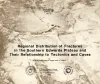
Regional distribution of fractures in the southern Edwards Plateau and their relationship to tectonics and caves |
Wermund, E.G., Cepeda, J.C., Luttrell, P.E. |
1977 |
Geological Circular |

|
A New Systematic Arrangement for Philodryas serra (Schlegel) and Philodryas pseudoserra Amaral |
|
1977 |
Texas Memorial Museum |
|
Catahoula Formation of the Texas coastal plain: depositional systems, composition, structural development, ground-water flow history, and uranium distribution |
Galloway, W.E., Murphy, T.D., Belcher, R.C., Johnson, B.D., Sutton, Stanley |
1977 |
Report of Investigations |
|
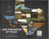
Land resources of Texas |
Kier, R.S., Garner, L.E., Brown, L.F., Jr., University of Texas at Austin, Bureau of Economic Geology |
1977 |
Selected Reports |
|
Tectonic map of the Rio Grande area, Trans-Pecos Texas and adjacent Mexico |
Henry, C.D., Bockoven, N.T. |
1977 |
Miscellaneous Map |
|
GCAGS Transactions Volume 27 (1977) Austin |
|
1977 |
Gulf Coast Association of Geological Societies |
|
Annual Report of the Bureau of Economic Geology 1977 |
University of Texas at Austin, Bureau of Economic Geology |
1977 |
Annual Reports |
|
Geology of the Click Quadrangle, Llano and Blanco Counties, Texas |
Barnes, V.E. |
1977 |
Geologic Quadrangle Map |
|
Shoreline changes on Mustang Island and North Padre Island (Aransas Pass to Yarborough Pass) -- an analysis of historical changes of the Texas Gulf shoreline |
Morton, R.A., Pieper, M.J. |
1977 |
Geological Circular |
|
Shoreline changes on central Padre Island (Yarborough Pass to Mansfield Channel) -- an analysis of historical changes of the Texas Gulf shoreline |
Morton, R.A., Pieper, M.J. |
1977 |
Geological Circular |
|
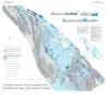
Environmental geologic Atlas of the Texas coastal zone -- Kingsville area |
Brown, L.F., Jr., McGowen, J.H., Evans, T.J., Groat, C.G., Fisher, W.L. |
1977 |
Environmental Geologic Atlas of the Texas Coastal Zone |
|
The Gulf shoreline of Texas: processes, characteristics, and factors in use |
McGowen, J.H., Garner, L.E., Wilkinson, B.H. |
1977 |
Geological Circular |
|
Hydrogeology of Gulf coast aquifers, Houston-Galveston area, Texas |
Kreitler, C.W., Guevara, E.H., Granata, G.E., McKalips, D.G. |
1977 |
Geological Circular |

|
Geologic Atlas of Texas, Pecos sheet |
Barnes, V.E., Eifler, G.K., Shell Oil Co., Cities Service Petroleum Co., Brown, J.B. |
1976 |
Geologic Atlas of Texas |