|
GCAGS Transactions Volume 28 (1978) New Orleans |
|
1978 |
Gulf Coast Association of Geological Societies |
|
Annual Report of the Bureau of Economic Geology 1978 |
University of Texas at Austin, Bureau of Economic Geology |
1978 |
Annual Reports |
|
Lower Cretaceous Carbonate Tidal Facies of Central Texas |
Loucks, R.G., Scott, A.J., Bebout, D.G., Mench, P.A. |
1978 |
Research Note |
|
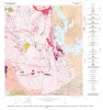
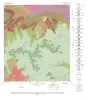
Geology of the Dunman Mountain Quadrangle, Llano, Burnet, and Blanco Counties, Texas |
Barnes, V.E. |
1978 |
Geologic Quadrangle Map |
|
Epeiric depositional models for the Lower Cretaceous Washita Group, north-central Texas |
Scott, R.W., Fee, D., Magee, R., Laali, Hooman |
1978 |
Report of Investigations |
|
Evaluating the Environmental Geology Map, Environmental Geologic Atlas of the Texas Coastal Zone |
Finley, R.J. |
1978 |
Research Note |
|
Geology of the Cap Mountain Quadrangle, Llano County, Texas |
Barnes, V.E. |
1978 |
Geologic Quadrangle Map |
|
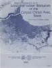
Land and water resources of the Corpus Christi area, Texas |
Kier, R.S., White, W.A. |
1978 |
Report of Investigations |
|
Stratigraphic Occurrence and Correlation of Early Tertiary Vertebrate Faunas, Trans-Pecos Texas |
|
1978 |
Texas Memorial Museum |
|
Hydrology of the Corpus Christi Area, Texas |
Woodman, J.T., Kier, R.S., Bell, D.L. |
1978 |
Research Note |
|
Geology of the Howell Mountain quadrangle, Blanco and Llano Counties, Texas |
Barnes, V.E. |
1978 |
Geologic Quadrangle Map |
|
Lower Cenomanian and Late Albian (Cretaceous) Ammonites, Especially Lyelliceridae, of Texas and Mexico |
|
1978 |
Texas Memorial Museum |
|
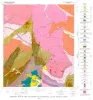
Geologic map of the Round Mountain quadrangle, Blanco, Burnet, and Llano counties. Texas |
Barnes, V.E. |
1978 |
Geologic Quadrangle Map |
|
Electric Power Generation from Texas Lignite |
Kaiser, W.R. |
1978 |
Geological Circular |
|
A Dasyleptid from the Permian of Kansas |
|
1978 |
Texas Memorial Museum |
|
Catahoula Formation of the Texas coastal plain: depositional systems, composition, structural development, ground-water flow history, and uranium distribution |
Galloway, W.E., Murphy, T.D., Belcher, R.C., Johnson, B.D., Sutton, Stanley |
1977 |
Report of Investigations |
|
Land resources of Texas |
Kier, R.S., Garner, L.E., Brown, L.F., Jr., University of Texas at Austin, Bureau of Economic Geology |
1977 |
Selected Reports |
|
Tectonic map of the Rio Grande area, Trans-Pecos Texas and adjacent Mexico |
Henry, C.D., Bockoven, N.T. |
1977 |
Miscellaneous Map |
|
GCAGS Transactions Volume 27 (1977) Austin |
|
1977 |
Gulf Coast Association of Geological Societies |
|
Annual Report of the Bureau of Economic Geology 1977 |
University of Texas at Austin, Bureau of Economic Geology |
1977 |
Annual Reports |