Publication Details
Geolocation:
Get the Publication
Abstract/Description:
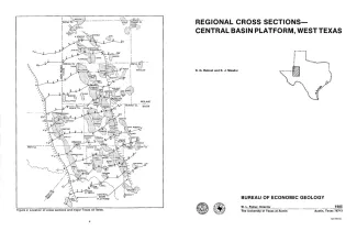
In 1982, the Bureau of Economic Geology initiated a project to characterize the major oil fields of Texas. The project led to the compilation of an atlas summarizing the general geologic setting and production statistics of all fields that have produced more than 10 million barrels of oil (Galloway and others, 1983). During this compilation, the need arose for regional stratigraphic control for the various large fields on the Central Basin Platform, and these cross sections were constructed to fill this need. Well logs (mostly gamma ray/neutron, but also electrical and sonic} from wells spaced approximately 5 mi apart are included on the 11 cross sections. Only the deepest wells are used, and most reach the Ellenburger Formation. Wherever possible the sections are directed through the major oil fields those that have produced more than 10 million barrels of oil and logs from those fields are included on the sections. The zone or zones of production are indicated on the well representing each field. Correlations of the entire Paleozoic section (fig. 1) were obtained from other published cross sections (West Texas Geological Society, 1962, 1964), cross sections and paleontological data from proprietary company files, compilations of oil-field studies (Herald, 1957; Stipp, 1960; West Texas Geological Society, 1966, 1969), and the records of the University Lands Office, Midland, and Railroad Commission of Texas, Austin. Where deep wells were not available a tectonic map of Texas (Ewing, in preparation) was used to aid in placing the tap of the Ellenburger Formation. Many disconformities are recognized in the Paleozoic section of the Central Basin Platform. However, only the regional! unconformity at the base of the Wolfcampian Series, where the rocks of entire geologic systems are missing, is indicated on the sections. Major faults are shown on the cross sections, and they are all indicated to be vertical because of lack of detailed data on the dip of the fault planes. The locations of the faults were obtained from the sources cited above or were recognized through identification of abrupt changes in elevation of markers from one weil to the next; the faults shown on the sections correspond to the major faults on the tectonic map compiled by Ewing (in preparation). These regional cross sections are intended to be used for preliminary correlation or to obtain an introduction to the geology of the Central Basin Platform area (fig. 2). For detailed information ona local area, reference shouid be made to the sources of field studies cited above.