Publication Details
Geolocation:
Get the Publication
$10.00
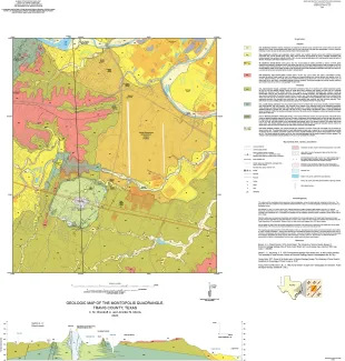
Abstract/Description:
This map presents a graphic means for engineers, planners, and property owners to recognize and cope with the changes in substrate properties across this fault zone. Fault displacement has created a profound and abrupt change in land-use capabilities in this area. That is, the stable ground of the Austin Group is juxtaposed against the weak, plastic claystone units that make up the Taylor and Navarro Groups of Upper Cretaceous age. The mapping also explores the occurrence of a Late Cretaceous marine volcano, Pilot Knob, that is exposed in the south-central part of this quadrangle. This feature offers great potential as a site for science education for adults as well as students of all ages. It also provides scientific context for the rocks visible in the nearby McKinney Falls State Park, which contains faulted limestone, volcanic ash deposits, and surface alluvial deposits.