Publications in Williamson
| Title | Publication Year Sort ascending | Abstract | Author | Series | Publisher | |
|---|---|---|---|---|---|---|
|
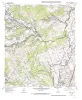
Geologic map of the Cobbs Cavern quadrangle, Texas | 1997 | Collins, E.W. | Open-File Map | Bureau of Economic Geology | |
|
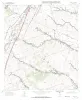
Geologic map of the Jarrell Quadrangle, Texas | 1997 | Collins, E.W. | Open-File Map | Bureau of Economic Geology | |
|
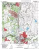
Geologic map of the Round Rock quadrangle, Texas | 1997 | Collins, E.W. | Open-File Map | Bureau of Economic Geology | |
|
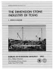
The dimension stone industry of Texas | 1992 | Garner, L.E. | Mineral Resource Circular | Bureau of Economic Geology | |
|
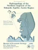
Hydrogeology of the northern segment of the Edwards aquifer, Austin region | 1990 | Geologic mapping and fracture analysis of the Lower Cretaceous Edwards aquifer strata near Georgetown and Round Rock, Texas, were performed to provide a better understanding of the geologic framework of the Balcones Fault Zone and to provide information for assessing ground-water flow characteris |
Senger, R.K., Collins, E.W., Kreitler, C.W. | Report of Investigations | Bureau of Economic Geology |

|
Environmental geology of the Wilcox Group lignite belt, east Texas | 1979 | This report provides a data base for decisions about lignite mining and reclamation in the Wilcox Group of East Texas. Kaiser (1974, 1978) estimates that about 12.2 billion short tons of potentially strip-minable lignite resources occur in East and South Texas. |
Henry, C.E., Basciano, J.M. | Report of Investigations | Bureau of Economic Geology |
|
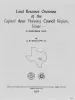
Land resource overview of the Capital Area Planning Council Region, Texas -- a nontechnical guide | 1979 | Bastrop, Blanco, Burnet, Caldwell, Fayette, Hays, Lee, Llano, Travis, and Williamson Counties make up the Capital Area Planning Council (CAPCO) region in Central Texas (fig. 1). The region covers 8,427 square miles (21,826 km2) and includes land of great physical diversity. |
Woodruff, C.M., Jr. | Selected Reports | Bureau of Economic Geology |
|
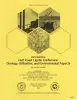
Proceedings, Gulf Coast Lignite Conference: Geology, Utilization, and Environmental Aspects | 1978 | Papers in this volume were presented at the Gulf Coast Lignite Conference held in Austin, Texas, June 1976. |
Kaiser, W.R., McNulty, J.E. | Report of Investigations | Bureau of Economic Geology |
|
Guide to points of geologic interest in Austin | 1976 | Trippet, A.R., Garner, L.E. | Guidebook | Bureau of Economic Geology | |
|
Calvert Bluff (Wilcox Group) sedimentation and the occurrence of lignite at Alcoa and Butler, Texas | 1976 | In east-central Texas, or the area between the Colorado |
Kaiser, W.R. | Research Note |