Publications in Red River
| Title | Publication Year Sort ascending | Abstract | Author | Series | Publisher | |
|---|---|---|---|---|---|---|

|
Depositional systems in the Nacatoch Formation (Upper Cretaceous), northeast Texas and southwest Arkansas | 1983 | The Nacatoch Formation of the East Texas Basin is the middle formation of the Navarro Group and consists of marine sandstones and mudstones derived largely from source areas to the northwest, north, and northeast of the East Texas Embayment. |
McGowan, M.K., Lopez, C.M. | Report of Investigations | Bureau of Economic Geology |
|
Geology and geohydrology of the east Texas basin -- a report on the progress of nuclear waste isolation feasibility studies (1980) | 1981 | The third year of research was highlighted by the integration of regional basinal studies with growth histories for specific domes, studies of cap-rock diagenesis and salt deformation, preliminary studies of ground-water flow and geochemistry around Oakwood Dome, and preliminary studies of micros |
Kreitler, C.W., Collins, E.W., Davidson, E.D., Dix, O.R., Donaldson, G.A., Dutton, S.P., Fogg, G.E., Giles, A.B. | Geological Circular | Bureau of Economic Geology |
|
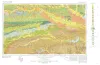
Geologic Atlas of Texas, Texarkana sheet (reprinted 1979 with base revised) | 1966 | Geologic map that depicts the surface geology of Lamar, Red River, Bowie, Delta, and Titus Counties and parts of Fannin, Hunt, Camp, Cass, Hopkins, Franklin, and Morris Counties, Texas. The 6-page booklet indicates geologic formations, abbreviations, and ages. |
Barnes, V.E., Humble Oil and Refining Co., Shell Oil Co., Pan American Petroleum Corp., Arkansas Geological and Conservation Commission, Oklahoma Geological Survey, McCallum, H.D., Wendlandt, E.A. | Geologic Atlas of Texas | Bureau of Economic Geology |
|
Rock and mineral resources of east Texas | 1965 | In the past 100 years, more than 100 names have been used to designate parts or all of the outcropping Midway and Wilcox rocks in the Gulf Coastal Plain; less than half of these names are used currently by Coastal Plain geologists, and the validity of some of the remaining named rock units has be |
Fisher, W.L., Chelf, C.R., Shelby, C.A., Garner, L.E., Owen, D.E., Shofield, D.A. | Report of Investigations | Bureau of Economic Geology |
|
Underground waters and subsurface temperatures of the Woodbine sand in northeast Texas | 1931 | Plummer, F.B., Sargent, E.C. | UT Bulletin | ||
|
Some Well Records in Red River County Texas | 1929 | These circulars issued from the Bureau of Economic Geology contain the record of cores and cuttings from well received and described in the Bureau. |
Well Record |