Publications in Presidio
| Title | Publication Year Sort ascending | Abstract | Author | Series | Publisher | |
|---|---|---|---|---|---|---|
|
Calderas and mineralization: volcanic geology and mineralization in the Chinati caldera complex, Trans-Pecos Texas | 1981 | This report describes preliminary results of an ongoing study of the volcanic stratigraphy, caldera activity, and known and potential mineralization of the Chinati Mountains area of Trans-Pecos Texas. Many ore deposits are spatially associated with calderas and other volcanic centers. |
Duex, T.W., Henry, C.D. | Geological Circular | Bureau of Economic Geology |
|
Structure of the Presidio Bolson area, Texas, interpreted from gravity data | 1980 | Mraz, J.R., Keller, G.R. | Geological Circular | Bureau of Economic Geology | |
|
Geologic setting and geochemistry of thermal water and geothermal assessment, Trans-Pecos Texas | 1979 | Hot springs and wells in West Texas and adjacent Mexico are manifestations of active convective geothermal systems concentrated in a zone along the Rio Grande between the Quitman Mountains and Big Bend National Park. |
Henry, C.D. | Report of Investigations | Bureau of Economic Geology |
| |
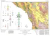
Geologic Atlas of Texas, Emory Peak-Presidio sheet | 1979 | Geologic map that depicts the surface geology of parts of Presidio, Brewster, and Terrell Counties, Texas. The 14-page booklet indicates geologic formations, abbreviations, and ages. |
Barnes, V.E., Geophoto Services Inc., Cities Service Petroleum Co., Mobil Oil Co., Cepeda, N.J., Daugherty, F.W., Brown, J.B., Norman, D.B. | Geologic Atlas of Texas | Bureau of Economic Geology |
|
Geologic Atlas of Texas, Marfa sheet | 1979 | Geologic map that depicts surface geology of parts of Hudspeth, Culberson, Jeff Davis, and Presidio Counties, Texas. The 12-page explanatory booklet indicates geologic formations, abbreviations, and ages. |
Barnes, V.E., Twiss, P.C., Continental Oil Co., Cities Service Petroleum Co., Geophoto Services Inc., Norman, D.M., Sherrod, C.H., Pearson, B.T. | Geologic Atlas of Texas | Bureau of Economic Geology |
|
Tectonic map of the Rio Grande area, Trans-Pecos Texas and adjacent Mexico | 1977 | Henry, C.D., Bockoven, N.T. | Miscellaneous Map | Bureau of Economic Geology | |
|
Gold and silver in Texas | 1975 | Evans, T.J. | Mineral Resource Circular | Bureau of Economic Geology | |
|
Mineral deposits in the west Chinati stock, Chinati Mountains, Presidio County, Texas | 1972 | The West Chinati stock, well exposed in San Antonio Canyon and immediately westward on slopes of the southwestern part of the Chinati Mountains, Presidio County, Texas, is a large stocklike body of porphyritic hornblende granite cut by numerous dikes and irregular-shaped plutons of rhyolite, rhyo |
McAnulty, W.N. | Geological Circular | Bureau of Economic Geology |
|
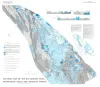
Presidio Bolson, Trans-Pecos Texas and adjacent Mexico: geology of a desert basin aquifer system | 1972 | Mountain-bounded basins or bolsons are the most important aquifer systems throughout most of southwestern and western United States and northern Mexico. |
Groat, C.G. | Report of Investigations | Bureau of Economic Geology |

|
Geologic map of the Bofecillos Mountains area, Trans-Pecos Texas | 1970 | The Bofecillos Mountains area of Trans-Pecos Texas contains a Tertiary volcanic vent and a varied sequence of lava flows, tuff, ash-flow tuff, and associated conglomerate, sandstone, and mudrock; after most of the volcanic activity had ceased, the area was block faulled and later dissected into a |
McKnight, J.F. | Geologic Quadrangle Map | Bureau of Economic Geology |