Publications in Presidio
| Title | Publication Year Sort ascending | Abstract | Author | Series | Publisher | |
|---|---|---|---|---|---|---|

|
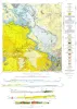
Geologic map of the Bofecillos Mountains area, Trans-Pecos Texas | 1970 | The Bofecillos Mountains area of Trans-Pecos Texas contains a Tertiary volcanic vent and a varied sequence of lava flows, tuff, ash-flow tuff, and associated conglomerate, sandstone, and mudrock; after most of the volcanic activity had ceased, the area was block faulled and later dissected into a |
McKnight, J.F. | Geologic Quadrangle Map | Bureau of Economic Geology |
|
Fluorspar in Brewster County, Texas | 1967 | Since production of fluorspar began in northern Coahuila, Mexico, in 1950-51, thousands of tons of high-grade ore have been mined from numerous deposits situated 5 to 75 miles south of the Rio Grande. |
McAnulty, W.N. | Geological Circular | Bureau of Economic Geology |
|
Geology of Presidio Area, Presidio County, Texas | 1966 | Dietrich, J.W. | Geologic Quadrangle Map | Bureau of Economic Geology | |
|
Tertiary formations of Rim Rock country, Presidio County, Trans-Pecos Texas | 1958 | The rim rock of the Vieja Rim, the quartz pantellerite of Lord, is named the Bracks Rhyolite. |
DeFord, R.K. | Report of Investigations | Bureau of Economic Geology |
|
Geology of the Pinto Canyon Area, Presidio County, Texas | 1958 | Amsbury, D.L. | Geologic Quadrangle Map | Bureau of Economic Geology | |
|
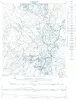
Tascotal Mesa Quadrangle, Brewster and Presidio Counties, Texas | 1953 | Erickson, R.L. | Miscellaneous Map | Bureau of Economic Geology | |
|
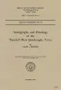
Stratigraphy and petrology of the Tascotal Mesa quadrangle, Texas | 1953 | The Tascotal Mesa quadrangle is in southeastern Presidio and southwestern Brewster counties, Trans Pecos Texas. Bandera Mesa and Tascotal Mesa are reached most easily from Marfa, 50 miles north, by the Marfa-Lajitas road which traverses the quadrangle from north to south. |
Erickson, R.L. | Report of Investigations | Bureau of Economic Geology |
|
Geologic map of Chinati Peak quadrangle, Presidio County, Texas | 1953 | Rix, C.C. | Miscellaneous Map | Bureau of Economic Geology | |
|
Geologic map of the Solitario | 1933 | Sellards, E.H., Adkins, W.S., Arick, M.B. | Miscellaneous Map | Bureau of Economic Geology | |
|
Exploratory geology of a part of southwestern Trans-Pecos Texas | 1927 | Baker, C.L. | UT Bulletin | Bureau of Economic Geology |