Publications in Presidio
| Title | Publication Year Sort ascending | Abstract | Author | Series | Publisher | |
|---|---|---|---|---|---|---|
|
Down to earth at Big Bend Ranch State Park, Texas: geologic map and trail-side geology | 2002 | This full-color, oversize map, designed for hikers in the park, describes geologic units and features. The text documents the geologic history of the Big Bend Ranch State Park area. Support was provided by the Texas Parks and Wildlife Department and the U.S. Geological Survey. |
Henry, C.D., Raney, J.A. | Down To Earth | Bureau of Economic Geology |
|
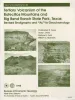
Tertiary volcanism of the Boficillos Mountains and Big Bend Ranch State Park, Texas: revised stratigraphy and 40Ar/39Ar geochronology | 1998 | The Bofecillos Mountains and Big Bend Ranch State Park contain a complex sequence of volcanic, volcaniclastic, and intrusive rocks that erupted from sources both within and outside the area. |
Henry, C.D., Davis, L.L., Kunk, M.J., McIntosh, W.C. | Report of Investigations | Bureau of Economic Geology |
|
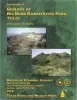
Geology of Big Bend Ranch State Park, Texas | 1998 | Big Bend Ranch State Park, the largest in the Texas State Parks System, lies in the rugged Big Bend country of West Texas (figs. 1 and 2). The primary attraction of Big Bend country is its scenery, and scenery is geology. |
Henry, C.D. | Guidebook | Bureau of Economic Geology |
|
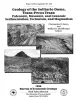
Geology of the Solitario dome, Trans-Pecos Texas: Paleozoic, Mesozoic, and Cenozoic sedimentation, tectonism, and magmatism | 1996 | The Solitario is a circular, 14- to 16-krn-diameter, mid-Tertiary laccolithic dome and caldera in southern Trans-Pecos Texas; it is among the world's largest laccoliths. |
Henry, C.D., Muehlberger, W.R., McCormick, C.L., Smith, C.I., Erdlac, R.J., Davis, L.L., Kunk, M.J. | Report of Investigations | Bureau of Economic Geology |
|
Geology of the Infiernito caldera and magmatic evolution of the Chinati Mountains, Trans-Pecos Texas | 1992 | The 37-Ma-old Infiernito caldera of the northern Chinati Mountains is a major eruptive center of the mid-Tertiary volcanic field of Trans-Pecos Texas. Volcanism in the Chinati Mountains began with eruption of a sequence of rhyolitic to trachytic lavas, the precollapse lavas. |
Henry, C.D., Price, J.G., Duex, T.W., James, E.W. | Report of Investigations | Bureau of Economic Geology |
|
Compilation of potassium-argon ages of Tertiary igneous rocks, Trans-Pecos Texas | 1986 | This compilation of potassium-argon (K-Ar) ages of igneous rocks of the Tertiary volcanic field of Trans-Pecos Texas includes all published ages known to us as well as many unpublished results. |
Henry, C.D., McDowell, F.W., Price, J.G., Smyth, R.C. | Geological Circular | Bureau of Economic Geology |
|
Tectonic map of the Basin and Range Province of Texas and adjacent Mexico | 1985 | Henry, C.D., Price, J.G., Gluck, J.K., Bockoven, N.T. | Miscellaneous Map | Bureau of Economic Geology | |
|
Annotated bibliography of mineral deposits in Trans-Pecos Texas | 1983 | Price, J.G., Henry, C.D., Standen, A.R. | Mineral Resource Circular | Bureau of Economic Geology | |
|
Oligocene volcanism and multiple caldera formation in the Chinati Mountains, Presidio County, Texas | 1983 | The Chinati Mountains caldera, which lies in Trans-Pecos Texas in the southern Basin and Range Province, was formed by eruption of the Mitchell Mesa Rhyolite. |
Cepeda, J.C., Henry, C.D. | Report of Investigations | Bureau of Economic Geology |
|
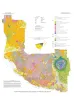
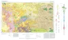
Geologic Atlas of Texas, Fort Stockton sheet (revised 1994) | 1982 | Geologic map that depicts the surface geology of parts of Jeff Davis, Reeves, Pecos, Terrell, Brewster, and Presidio Counties, Texas. The 9-page booklet indicates geologic formations, abbreviations, and ages. |
Barnes, V.E., Humboldt Oil and Refining Co., Mobil Oil Co., Geophoto Services Inc., Cities Service Petroleum Co., Anderson, J.E., Brown, J.B., Gries, J.C. | Geologic Atlas of Texas | Bureau of Economic Geology |