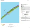
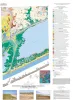
Publications in Matagorda
Title | Publication Year Sort ascending | Abstract | Author | Series | Publisher | |
---|---|---|---|---|---|---|
![]() |
Geologic map of the Palacios NE quadrangle, Texas Gulf of Mexico Coast | 2022 | Paine, J.G., Costard, L. | Open-File Map | Bureau of Economic Geology | |
![]() |
Geologic map of the Palacios SE quadrangle, Texas Gulf of Mexico Coast | 2022 | Paine, J.G., Costard, L., Caudle, T.L. | Open-File Map | Bureau of Economic Geology | |
![]() |
Geologic map of the Palacios and part of the Palacios Point quadrangles, Texas Gulf of Mexico coast | 2021 | Paine, J.G., Costard, L. | Open-File Map | Bureau of Economic Geology | |
![]() |
Geologic map of the Turtle Bay quadrangle, Texas Gulf of Mexico coast | 2021 | Paine, J.G., Costard, L. | Open-File Map | Bureau of Economic Geology | |
![]() |
Geologic map of the Olivia and part of the Keller Bay quadrangles, Texas Gulf of Mexico coast | 2020 | Paine, J.G., Costard, L. | Open-File Map | Bureau of Economic Geology | |
![]() |
Geologic map of Port O'Connor quadrangle, Texas Gulf of Mexico coast | 2016 | Paine, J.G., Collins, E.W. | Open-File Map | Bureau of Economic Geology | |
![]() |
Geoenvironmental map of Matagorda - Matagorda SW quadrangles, Texas Gulf of Mexico Coast | 2011 | Tremblay, T.A., Collins, E.W., Paine, J.G. | Open-File Map | Bureau of Economic Geology | |
![]() |
Core and Log Analyses of Depositional Systems and Reservoir Properties ... in Frio, Vicksburg, and Wilcox Sandstones | 1992 | The Gas Research Institute, U.S. Department of Energy, and the State of Texas cooperated in joint-venture research to evaluate the infield reserve growth potential of mature gas fields containing conventional reservoirs. |
Levey, R.A., Grigsby, J.D. | Geological Circular | Bureau of Economic Geology |
![]() |
Submerged lands of Texas, Port Lavaca area: sediments, geochemistry, benthic macroinvertebrates, and associated wetlands | 1989 | 
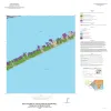
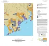
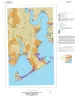
The State-owned submerged lands of Texas encompass almost 6,000 mi2 (15,540 km2). They lie below waters of the bay-estuary-lagoon system and the Gulf of Mexico and extend 10.3 mi (16.6 km) seaward from the Gulf shoreline (fig. 1). |
White, W.A., Calnan, T.R., Morton, R.A., Kimble, R.S., Littleton, T.G., McGowen, J.H., Nance, H.S. | Submerged Lands of Texas | Bureau of Economic Geology |
![]() |
Shoreline and vegetation-line movement, Texas Gulf coast, 1974 to 1982 | 1989 | The purposes of this study were (1) to quantify recent (1974 to 1982) movement of Texas shorelines and vegetation lines by analysis of aerial photographs; (2) to place this movement in historical (pre-1974) context; and (3) to examine the influence of environmental variables such as storms, sea l |
Paine, J.G., Morton, R.A. | Geological Circular | Bureau of Economic Geology |