Publications in Comal
| Title | Publication Year Sort ascending | Abstract | Author | Series | Publisher | |
|---|---|---|---|---|---|---|
|
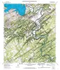
Geologic map of the Sattler quadrangle, Texas | 1991 | Collins, E.W., Baumgardner, R.W., Jr., Raney, J.A. | Open-File Map | Bureau of Economic Geology | |
|
The Guadalupe - Lavaca - San Antonio - Nueces River basins regional study: San Antonio East - Llano East sheets | 1985 | Wermund, E.G., Gustavson, T.C., Garner, L.E., Morton, R.A., Woodruff, C.M., Jr., Macpherson, G.L., McKinney, L., Nilsson, J. | River Basins Regional Studies | Bureau of Economic Geology | |
|
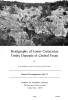
Depositional and diagenetic history of the Sligo and Hosston Formations(Lower Cretaceous) in south Texas | 1981 | The Sligo and Hosston Formations of Aptian age occur over thousands of square miles in the subsurface of South Texas. |
Bebout, D.G., Budd, D.A., Schatzinger, R.A. | Report of Investigations | Bureau of Economic Geology |
|
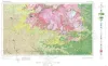
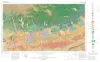
Geologic Atlas of Texas, Llano sheet | 1981 | Geologic map that depicts the surface geology of Mason, Llano, and Gillespie Counties and parts of Menard, Kimble, San Saba, McCulloch, Edwards, Real, Kerr, Kendall, Blanco, Hays, Travis, Williamson, and Burnet Counties, Texas. |
Barnes, V.E., Shell Oil Co., Boyer, R.E., Clabaugh, S.E., Baker, E.T. | Geologic Atlas of Texas | Bureau of Economic Geology |
|
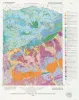
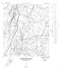
Geologic Atlas of Texas, San Antonio sheet (revised 1982) | 1974 | Geologic map that depicts the surface geology of Comal, Bandera, Bexar, and Medina Counties and parts of Real, Kerr, Kendall, Hays, Guadalupe, Wilson, Atascosa, Frio, Zavala, and Uvalde Counties, Texas. The 9-page booklet indicates geologic formations, abbreviations, and ages. |
Barnes, V.E., Shell Oil Co., Amerada Petroleum Corp., Brown, T.E., Waechter, N.B., Dillon, R.L. | Geologic Atlas of Texas | Bureau of Economic Geology |
|
Stratigraphy of Lower Cretaceous Trinity deposits of central Texas | 1971 | The stratigraphic record of the Lower Cretaceous Trinity Division in Central Texas, as revealed by extensive outcrop investigation, is that of a shallow sea transgressing the southern flank of the ancient Llano Uplift. |
Stricklin, F.L., Smith, C.I., Lozo, F.E. | Report of Investigations | Bureau of Economic Geology |
|
Geologic Maps, Central Texas (selected areas), 1957 and 1959 | 1957 | Fourteen black-and-white geologic maps prepared in 1957 and 1959 and obtained from the Department of Geological Sciences, University of Texas, and sold by the Bureau of Economic Geology. Geology compiled by F. L. Whitney; drafted by S. Espey, W. M. Strong, or W. L. Brooks; edited by K. P. |
Whitney, F.L. | Miscellaneous Map | Bureau of Economic Geology |
|
Igneous rocks of the Balcones fault region of Texas | 1927 | Lonsdale, J.T. | UT Bulletin |