Publications in Bell
| Title | Publication Year Sort ascending | Abstract | Author | Series | Publisher | |
|---|---|---|---|---|---|---|
|
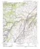
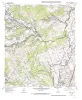
Geologic map of the west half of the Taylor, Texas, 30 X 60 minute quadrangle: central Texas urban corridor, encompassing Round Rock, Georgetown, Salado, Briggs, Liberty Hill, and Leander | 2005 | Collins, E.W. | Miscellaneous Map | Bureau of Economic Geology | |
|
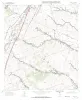
Geologic map of the Briggs quadrangle, Texas | 1999 | Collins, E.W. | Open-File Map | Bureau of Economic Geology | |
|
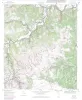
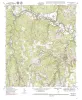
Geologic map of the Ding Dong Quadrangle, Texas | 1998 | Collins, E.W. | Open-File Map | Bureau of Economic Geology | |

|
Geologic map of the Youngsport Quadrangle, Texas | 1998 | Collins, E.W. | Open-File Map | Bureau of Economic Geology | |
|
Geologic map of the Salado Quadrangle, Texas | 1998 | Collins, E.W. | Open-File Map | Bureau of Economic Geology | |
|
Geologic map of the Cobbs Cavern quadrangle, Texas | 1997 | Collins, E.W. | Open-File Map | Bureau of Economic Geology | |
|
Geologic map of the Jarrell Quadrangle, Texas | 1997 | Collins, E.W. | Open-File Map | Bureau of Economic Geology | |
|
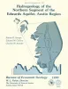
Hydrogeology of the northern segment of the Edwards aquifer, Austin region | 1990 | Geologic mapping and fracture analysis of the Lower Cretaceous Edwards aquifer strata near Georgetown and Round Rock, Texas, were performed to provide a better understanding of the geologic framework of the Balcones Fault Zone and to provide information for assessing ground-water flow characteris |
Senger, R.K., Collins, E.W., Kreitler, C.W. | Report of Investigations | Bureau of Economic Geology |
|
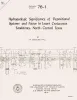
Hydrogeologic significance of depositional systems and facies in Lower Cretaceous sandstones, north-central Texas | 1976 | The Lower Cretaceous Hosston and Hensel Sandstones are important sources of ground water in North-Central Texas. |
Hall, W.D. | Geological Circular | Bureau of Economic Geology |
|
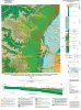
Geologic Atlas of Texas, Austin sheet | 1974 | Geologic map that depicts the surface geology of Burleson, Lee, Washington, and Brazos Counties and parts of Burnet, Bell, Milam, Robertson, Madison, Grimes, Waller, Austin, Fayette, Bastrop, Caldwell, Hays, Travis, and Williamson Counties. |
Barnes, V.E., Shell Oil Co., Humble Oil and Refining Co., Mobil Oil Co., Proctor, C.V., Jr., Brown, T.E., McGowen, J.H., Waechter, N.B. | Geologic Atlas of Texas | Bureau of Economic Geology |