Publications in Bell
| Title | Publication Year Sort ascending | Abstract | Author | Series | Publisher | |
|---|---|---|---|---|---|---|
|
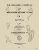
The Edwards reef complex and associated sedimentation in central Texas | 1973 | The Fredericksburg Group is one of three groups of rocks which comprise the outcropping Lower Cretaceous sediments in north central Texas. Four formations form this group; from the base upward these are the Paluxy, Walnut, Comanche Peak and Edwards (fig. 1). |
Nelson, H.F. | Guidebook | Bureau of Economic Geology |
|
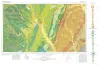
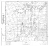
Geologic Atlas of Texas, Waco sheet | 1970 | Geologic maps that depicts the surface geology of McLennan, Limestone, and Falls Counties and parts of Bosque, Hill, Navarro, Freestone, Leon, Madison, Robertson, Milam, Bell, Lampasas, Coryell, and Hamilton Counties, Texas. |
Barnes, V.E., Humble Oil and Refining Co., Shell Oil Co., Mobil Oil Co., Proctor, C.V., Jr., McGowen, J.H., Haenggi, W.T., Hayward, O.T. | Geologic Atlas of Texas | Bureau of Economic Geology |
|
Nomenclature revision of basal Cretaceous rocks between the Colorado and Red Rivers, Texas | 1966 | Based on need for convenient, small-scale cartographic units, the basal Cretaceous rocks in Texas from Red River to Burnet County and on the Callahan Divide are herein divided into three distinctive lithologic sequences. |
Fisher, W.L., Rodda, P.U. | Report of Investigations | Bureau of Economic Geology |
|
Stratigraphy of the Fredericksburg Division, south-central Texas | 1964 | Sediments of the Fredericksburg Division in south-central Texas were deposited on the slowly subsiding west flank of the Tyler basin. In this region there are three stratigraphically distinct areas. The southern area has a thick Edwards Limestone unit overlying a thin Walnut Formation. |
Moore, C.H. | Report of Investigations | Bureau of Economic Geology |
|
Symposium on Edwards Limestone in Central Texas | 1959 | Lozo, F.E., Nelson, H.F., Young, Keith, Shelburne, O.B., Sandidge, J.R. | UT Publication | ||
|
Report on River Terraces in Bell County, Texas, as a Part of a Mineral Resource Survey | 1936 | The largest stream in Bell County is Little River, which is formed by the confluence of Leon and Lampasas rivers southeast of Belton and nearly south of Temple. |
Nickell, C.O. | Mineral Resource Survey Circulars | |
|
Geology of Bell County, Texas | 1930 | Adkins, W.S., Arick, M.B. | UT Bulletin | ||
|
Mineral Resources of Bell County Texas | 1929 | Bell County is partly within the Gulf Coastal Plain and is crossed by the Balcones zone of faulting. West of this fault zone, the surface formations are those of the Comanche Cretaceous, while to the east of the fault zone, the formations are largely those of the Gulf series or Upper Cretaceous. |
Adkins, W.S. | Mineral Resource Pamphlet | |
|
Selected Texas County Maps, 1929-1937 | 1929 | These are 21 Texas county maps made in cooperation with the American Association of Petroleum Geologists and Society of Economic Paleontologists and Mineralogists, issued between 1929 and 1932 and revised in 1937. |
Miscellaneous Map | Bureau of Economic Geology | |
|
Well Records of Bell County Texas | 1928 | These circulars issued from the Bureau of Economic Geology contain the record of cores and cuttings from well received and described in the Bureau. |
Well Record |