Publications by Shell Oil Co.
| Title | Publication Year Sort ascending | Abstract | Author | Series | Publisher | |
|---|---|---|---|---|---|---|
|
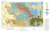
Geologic Atlas of Texas, Big Spring sheet (revised 1994) | 1974 | Geologic map that depicts the surface geology of Borden, Scurry, Fisher, Martin, Howard, Mitchell, and Nolan Counties and parts of Glasscock, Sterling, Coke, Runnels, Taylor, Jones, Dawson, Martin, Lynn, Garza, Kent, and Stonewall Counties. |
Eifler, G.K., Frye, J.C., Leonard, T.F., Barnes, V.E., Trollinger-Gusney and Assoc., Shell Oil Co., Humble Oil and Refining Co., Southern Minerals Corp. | Geologic Atlas of Texas | Bureau of Economic Geology |

|
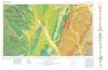
Geologic Atlas of Texas, Abilene sheet | 1972 | Geologic map that depicts the surface geology of Shackelford, Stephens, Palo Pinto, Callahan, and Eastland Counties and parts of Jones, Taylor, Runnels, Coleman, Brown, Comanche, Erath, Parker, and Hood Counties, Texas. |
Barnes, V.E., Brown, L.F., Jr., Goodson, J.L., Southern Minerals Corp., Humble Oil and Refining Co., Shell Oil Co., Harwood, P., Bloomer, R.R. | Geologic Atlas of Texas | Bureau of Economic Geology |

|
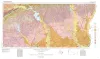
Geologic Atlas of Texas, Dallas sheet (revised 1987) | 1972 | Geologic map that depicts surface geology of Tarrant, Dallas, Kaufman, Ellis, Johnson, Somervell, and Rockwall Counties and parts of Parker, Hood, Erath, Bosque, Hill, Navarro, Henderson, Van Zandt, and Hunt Counties, Texas. |
Barnes, V.E., Shell Oil Co., Humble Oil and Refining Co., Dallas Geological Society, Fort Worth Geological Society, McGowen, J.H., Proctor, C.V., Jr., Haenggi, W.T. | Geologic Atlas of Texas | Bureau of Economic Geology |
|
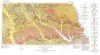
Geologic Atlas of Texas, Waco sheet | 1970 | Geologic maps that depicts the surface geology of McLennan, Limestone, and Falls Counties and parts of Bosque, Hill, Navarro, Freestone, Leon, Madison, Robertson, Milam, Bell, Lampasas, Coryell, and Hamilton Counties, Texas. |
Barnes, V.E., Humble Oil and Refining Co., Shell Oil Co., Mobil Oil Co., Proctor, C.V., Jr., McGowen, J.H., Haenggi, W.T., Hayward, O.T. | Geologic Atlas of Texas | Bureau of Economic Geology |

|
Geologic Atlas of Texas, Plainview sheet (revised 1992) | 1968 | Geologic map that depicts surface geology of Swisher, Briscoe, Hall, and Childress Counties and parts of Randall, Armstrong, Donley, Collingsworth, Hale, Floyd, Motley, and Cottle Counties. |
Barnes, V.E., Humble Oil and Refining Co., Shell Oil Co., Eifler, G.K., Knight, G.L., Hughes, C.D., Horn, P.H., Quackenbush, W.M. | Geologic Atlas of Texas | Bureau of Economic Geology |
|
Geologic Atlas of Texas, Beaumont sheet (revised 1992) | 1968 | Geologic map that depicts the surface geology of Montgomery, San Jacinto, and Hardin Counties and parts of Madison, Trinity, Polk, Tyler, Jasper, Newton, Orange, Jefferson, Liberty, Harris, Waller, Grimes, Walker, and Robertson Counties. |
Barnes, V.E., Humble Oil and Refining Co., Shell Oil Co., Aronow, Saul, Shelby, C.A., Eargle, D.H., LeBlanc, R.J., Evans, F.G. | Geologic Atlas of Texas | Bureau of Economic Geology |
| |
Geologic Atlas of Texas, Van Horn-El Paso sheet (revised 1983) | 1968 | Geologic map that depicts the surface geology of El Paso County and parts of Hudspeth. Jeff Davis, and Culberson Counties, Texas. The 12-page booklet indicates geologic formations, abbreviations, and ages. Published in honor of E. |
Barnes, V.E., Shell Oil Co., Cities Service Petroleum Co., Dietrich, J.W., Owen, D.E., Shelby, C.A., Macon, J.W., Bridges, L.W. | Geologic Atlas of Texas | Bureau of Economic Geology |
|
Geologic Atlas of Texas, Palestine sheet (revised 1993) | 1967 | Geologic map that depicts the surface geology of Nacogdoches, Shelby, San Augustine, Sabine, and Angelina Counties and parts of Anderson, Cherokee, Rusk, Newton, Jasper, Tyler, Polk, Trinity, Robertson, Madison, Leon, Freestone, and Panola Counties, Texas. |
Barnes, V.E., Humble Oil and Refining Co., Shell Oil Co., Pan American Petroleum Corp., Mobil Oil Co., Wright, A.C., McCallum, H.D., Wendlandt, E.A. | Geologic Atlas of Texas | Bureau of Economic Geology |

|
Geologic Atlas of Texas, Texarkana sheet (reprinted 1979 with base revised) | 1966 | Geologic map that depicts the surface geology of Lamar, Red River, Bowie, Delta, and Titus Counties and parts of Fannin, Hunt, Camp, Cass, Hopkins, Franklin, and Morris Counties, Texas. The 6-page booklet indicates geologic formations, abbreviations, and ages. |
Barnes, V.E., Humble Oil and Refining Co., Shell Oil Co., Pan American Petroleum Corp., Arkansas Geological and Conservation Commission, Oklahoma Geological Survey, McCallum, H.D., Wendlandt, E.A. | Geologic Atlas of Texas | Bureau of Economic Geology |
|
Geologic Atlas of Texas, Tyler sheet | 1964 | Geologic map that depicts the surface geology of Rains, Wood, Upshur, Marion, Harrison, Smith, and Gregg Counties and parts of Camp, Cass, Panola, Rusk, Cherokee, Anderson, Henderson, Van Zandt, Hunt, Morris, Franklin, and Hopkins Counties, Texas. |
Barnes, V.E., Shell Oil Co., Humble Oil and Refining Co., Mobil Oil Co., Pan American Petroleum Corp., Eaton, R.W., Wright, A.C., McCallum, H.D. | Geologic Atlas of Texas | Bureau of Economic Geology |