Publications by Morton, R.A.
| Title | Publication Year Sort ascending | Abstract | Author | Series | Publisher | |
|---|---|---|---|---|---|---|
|
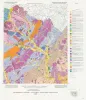
The Guadalupe - Lavaca - San Antonio - Nueces River basins regional study: Seguin West - Austin West sheets | 1985 | Wermund, E.G., Gustavson, T.C., Morton, R.A., Woodruff, C.M., Jr., Macpherson, G.L., McKinney, L., Nilsson, J., Waddell, C.T. | River Basins Regional Studies | Bureau of Economic Geology | |
|
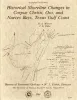
Historical shoreline changes in Corpus Christi, Oso, and Nueces Bays, Texas Gulf coast | 1984 | Changes in the position and stability of shorelines around Corpus Christi, Oso, and Nueces Bays, Texas Gulf Coast, were documented using historical-monitoring techniques. |
Morton, R.A., Paine, J.G., Robinson, D.E. | Geological Circular | Bureau of Economic Geology |
|
Enhanced gas recovery from watered-out reservoirs -- Port Arthur Field, Jefferson County, Texas | 1984 | Gas reservoirs that water out under moderate to strong water drives are normally abandoned when the expenses associated with salt-water disposal make continued operations uneconomical. |
Gregory, A.R., Lin, Z.S., Reed, R.S., Morton, R.A., Ewing, T.E. | Report of Investigations | Bureau of Economic Geology |
|
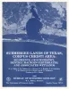
Submerged lands of Texas, Corpus Christi area: sediments, geochemistry, benthic macroinvertebrates, and associated wetlands | 1983 | The State-owned submerged lands of Texas encompass almost 6,000 mi2 (15,540 km2). They lie below waters of the bay-estuary-lagoon system and the Gulf of Mexico and extend 10.3 mi (16.6 km) seaward from the Gulf shoreline (fig. 1). |
White, W.A., Calnan, T.R., Morton, R.A., Kimble, R.S., Littleton, T.G., McGowen, J.H., Nance, H.S., Schmedes, K.E. | Submerged Lands of Texas | Bureau of Economic Geology |
|
Continuity and Internal Properties of Gulf Coast Sandstones and Their Implications for Geopressured Fluid Production | 1983 | Continuity of sandstone reservoirs is controlled by various factors, including faults, sand-body geometry, and the distribution of framework grains, matrices, and interstices within the sand body. |
Morton, R.A., Ewing, T.E., Tyler, Noel | Report of Investigations | Bureau of Economic Geology |
|
Depositional setting, structural style, and sandstone distribution in three geopressured geothermal areas, Texas Gulf Coast | 1983 | Three areas in the Texas Gulf Coastal Plain were studied using electric logs and seismic reflection data to interpret their depositional and structural history and to compare their potential as geopressured-geothermal reservoirs. |
Winker, C.D., Morton, R.A., Ewing, T.E., Garcia, D.D., Chong, L.P., Han, J.H., Lawton, J.L., Padilla y Sanchez, R.J. | Report of Investigations | Bureau of Economic Geology |
|
Distribution and significance of coarse biogenic and clastic deposits on the Texas inner shelf | 1980 | Sediments of the Texas inner shelf are generally fine grained; coarse clasts ( > 0.5 mm) are uncommon (< 1%) over much of the area. Higher concentrations of coarse material, however, occur in discrete areas that apparently represent positions of foyer deltas. |
Morton, R.A., Winker, C.D. | Geological Circular | Bureau of Economic Geology |
|
Modern depositional environments of the Texas coast | 1980 | The Texas Coastal Plain is ideal for studying physical processes and the late Quaternary sedimentological record. |
Morton, R.A., McGowen, J.H. | Guidebook | Bureau of Economic Geology |
|
The Queen City Formation in the East Texas embayment: a developmental record of riverine, tidal and wave interaction | 1980 | Five distinct facies are recognized in the Eocene Queen City exposures between the Trinity River valley and the Louisiana state boundary. These facies (fluvial, deltaic, tidal flat, barrier, and tidal delta) display diagnostic suites of physical and biogenic structures. |
Hobday, D.K., Morton, R.A., Collins, E.W. | Geological Circular | Bureau of Economic Geology |
|
Sediment distribution, bathymetry, faults, and salt diapirs, submerged lands of Texas | 1979 | The State-owned submerged lands of Texas encompass nearly 6,000 square miles (15,540 km²) and extend from Mexico to Louisiana. The area includes the bays, estuaries, and lagoons, as well as the inner continental shelf 10.3 miles (16.6 km) seaward of the Gulf shoreline (fig. 1). |
McGowen, J.H., Morton, R.A. | Selected Reports | Bureau of Economic Geology |