Publications by Morton, R.A.
| Title | Publication Year Sort ascending | Abstract | Author | Series | Publisher | |
|---|---|---|---|---|---|---|
|
Submerged lands of Texas, Beaumont - Port Arthur area: sediments, geochemistry, benthic macroinvertebrates, and associated wetlands | 1987 | The State-owned submerged lands of Texas encompass almost 6,000 mi2 (15,540 km2). They lie below waters of the bay-estuary-lagoon system and the Gulf of Mexico and extend 10.3 mi (16.6 km) seaward from the Gulf shoreline (fig. 1). |
White, W.A., Calnan, T.R., Morton, R.A., Kimble, R.S., Littleton, T.G., McGowen, J.H., Nance, H.S. | Submerged Lands of Texas | Bureau of Economic Geology |
|
Historical shoreline changes in San Antonio, Espiritu Santo, and Mesquite Bays, Texas Gulf coast | 1987 | Changes in the position and stability of shorelines in the San Antonio Bay system (San Antonio, Espiritu Santo, and Mesquite Bays), Texas Gulf Coast, were documented using historical monitoring techniques. |
White, W.A., Morton, R.A. | Geological Circular | Bureau of Economic Geology |
|
Lower Miocene (Fleming) depositional episode of the Texas coastal plain and continental shelf: structural framework, facies, and hydrocarbon resources | 1986 | The Fleming Group and its basinward equivalents constitute the stratigraphic record of one of the major Cenozoic depositional episodes of the northern Gulf Coast Basin. The depositional sequence representing the episode is bounded above by the Amphistegina B shale and below by the Anahuac shale. |
Galloway, W.E., Jirik, L.A., Morton, R.A., DuBar, J.R. | Report of Investigations | Bureau of Economic Geology |
|
Historical shoreline changes in Trinity, Galveston, West, and East Bays, Texas Gulf coast | 1986 | Changes in shoreline position occurring for more than a century provide estimates of the relative stability of shorelines and, along the Texas coast, allow comparisons of shoreline changes before and after human modifications became significant. |
Paine, J.G., Morton, R.A. | Geological Circular | Bureau of Economic Geology |
|
Submerged lands of Texas, Brownsville - Harlingen area: sediments, geochemistry, benthic macroinvertebrates, and associated wetlands | 1986 | The State-owned submerged lands of Texas encompass almost 6,000 mi2 (15,540 km2). They lie below waters of the bay-estuary-lagoon system and the Gulf of Mexico and extend 10.3 mi (16.6 km) seaward from the Gulf shoreline (fig. 1). |
White, W.A., Calnan, T.R., Morton, R.A., Kimble, R.S., Littleton, T.G., McGowen, J.H., Nance, H.S., Schmedes, K.E. | Submerged Lands of Texas | Bureau of Economic Geology |
|
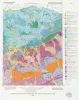
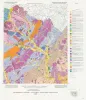
The Guadalupe - Lavaca - San Antonio - Nueces River basins regional study: San Antonio East - Llano East sheets | 1985 | Wermund, E.G., Gustavson, T.C., Garner, L.E., Morton, R.A., Woodruff, C.M., Jr., Macpherson, G.L., McKinney, L., Nilsson, J. | River Basins Regional Studies | Bureau of Economic Geology | |
|
The Guadalupe - Lavaca - San Antonio - Nueces River basins regional study: Seguin West - Austin West sheets | 1985 | Wermund, E.G., Gustavson, T.C., Morton, R.A., Woodruff, C.M., Jr., Macpherson, G.L., McKinney, L., Nilsson, J., Waddell, C.T. | River Basins Regional Studies | Bureau of Economic Geology | |
|
Depositional history, facies analysis, and production characteristics of hydrocarbon-bearing sediments, offshore Texas | 1985 | Large areas of offshore Texas remain unexplored even though sedimentary facies and structural traps favor the generation and accumulation of hydrocarbons. |
Morton, R.A., Jirik, L.A., Foote, R.Q. | Geological Circular | Bureau of Economic Geology |

|
Structural cross sections, Miocene series, Texas continental shelf | 1985 | These cross sections numerically correspond to previously published onshore cross sections (CS0002--Dodge and Posey, 1981) and extend those sections across the continental shelf into the Miocene, a recent target of renewed petroleum exploration. |
Morton, R.A., Jirik, L.A., Foote, R.Q. | Cross Sections | Bureau of Economic Geology |
|
Beach and vegetation-line changes at Galveston Island, Texas: erosion, deposition, and recovery from Hurricane Alicia | 1985 | On August 18, 1983, Hurricane Alicia crossed the upper Texas Gulf Coast and caused extensive property damage, especially along West Beach of Galveston Island. |
Morton, R.A., Paine, J.G. | Geological Circular | Bureau of Economic Geology |