Publications by McGowen, J.H.
| Title | Publication Year Sort ascending | Abstract | Author | Series | Publisher | |
|---|---|---|---|---|---|---|
|
Gum Hollow fan delta, Nueces Bay, Texas | 1971 | A study of Gum Hollow delta, a modern fan delta along the north shore of Nueces Bay, Texas, was undertaken to determine the mechanics of fan development and the relationships between sedimentary processes and structures. |
McGowen, J.H. | Report of Investigations | Bureau of Economic Geology |
|
Van Horn Sandstone, West Texas: an alluvial fan model for mineral exploration | 1971 | The Van Horn Sandstone in southwestern Culberson and southeastern Hudspeth counties, Texas, was studied in cooperation with the U.S. |
McGowen, J.H., Groat, C.G. | Report of Investigations | Bureau of Economic Geology |
|
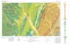
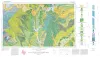
Geologic Atlas of Texas, Waco sheet | 1970 | Geologic maps that depicts the surface geology of McLennan, Limestone, and Falls Counties and parts of Bosque, Hill, Navarro, Freestone, Leon, Madison, Robertson, Milam, Bell, Lampasas, Coryell, and Hamilton Counties, Texas. |
Barnes, V.E., Humble Oil and Refining Co., Shell Oil Co., Mobil Oil Co., Proctor, C.V., Jr., McGowen, J.H., Haenggi, W.T., Hayward, O.T. | Geologic Atlas of Texas | Bureau of Economic Geology |
|
Effects of Hurricane Celia -- a focus on environmental geologic problems | 1970 | At 10 pm (CDT) on Friday, July 31, 1970, a tropical squall struck the western tip of Cuba causing property damage and the loss of 5 lives. Twelve hours later at 10 am (CDT), Saturday, August 1, the tropical depression had moved 150 miles northwest and had intensified into Tropical Storm Celia. |
McGowen, J.H., Groat, C.G., Brown, L.F., Jr., Fisher, W.L., Scott, A.J. | Geological Circular | Bureau of Economic Geology |
|
Physiographic Features and Stratification Types of Coarse-Grained Point Bars: Modern and Ancient Examples | 1970 | Primary sedimentary structures in modern point-bar deposits of the Amite River in Louisiana and the Colorado River in Texas are analogous to features observed in Eocene Simsboro and Pleistocene Colorado River deposits of the Texas Gulf Coastal Plain. |
McGowen, J.H., Garner, L.E. | Geological Circular | Bureau of Economic Geology |
|
Delta Systems in the Exploration for Oil and Gas | 1969 | This classic publication is a syllabus published in conjunction with a Research Colloquium of the Bureau of Economic Geology, August 27-29,1969. It includes discussion notes, 168 maps and other text figures, and a list of 321 selected references pertaining to modern and ancient delta systems. |
Fisher, W.L., Brown, L.F., Jr., Scott, A.J., McGowen, J.H. | Educational Material | Bureau of Economic Geology |
|
Depositional systems in the Wilcox Group of Texas and their relationship to occurrence of oil and gas | 1967 | Regional investigation of the lower part of the Wilcox Group in Texas in outcrop and subsurface indicates seven principal depositional systems. These include: (1) Mt. |
Fisher, W.L., McGowen, J.H. | Geological Circular | Bureau of Economic Geology |
|
Geologic Atlas of Texas, Sherman sheet (revised 1991) | 1967 | Geologic map that depicts the surface geology of Montague, Cooke, Grayson, Wise, Denton, and Collin Counties and parts of Jack, Fannin, Hunt, and Clay Counties, Texas. The 16-page booklet indicates geologic formations, abbreviations, and ages. |
McGowen, J.H., Hentz, T.F., Owen, D.E., Pieper, M.K., Shelby, C.A., Barnes, V.E., Humble Oil and Refining Co., Pure Oil Co. | Geologic Atlas of Texas | Bureau of Economic Geology |