
Annual report for the Bureau of Economic Geology 1963
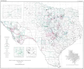
In planning for a modern geologic map of the State (scale 1:250,000), a bibliography of published and unpublished geologic maps of areas in Texas was compiled under the direction of Virgil E. Barnes, Director of the Geologic Atlas Project of the Bureau of Economic Geology. The area of those areal geologic maps with a scale of 1:250,000 or larger is outlined on the accompanying index map. The index map also shows the 1:250,000 scale Army Map Service 1 deg X 2 deg quadrangles, which serve as a base for the new Texas Geologic Atlas (see inset).
One of the basic mineral resources of Texas is abundant deposits of lignite in Eocene rocks of the Gulf Coastal Plain. Currently, Texas lignites are utilized as sources of industrial fuel, activated carbon and, locally, drilling mud additives; research indicates significant future nonfuel uses of lignite and lignitic coals.
The Red River rises in northeastern New Mexico and extends across northern Texas and east of the Panhandle serves as the northern border of that State. The late Cenozoic geology of the Red River basin has been studied intensively in northwestern Texas and in Louisiana. This report summarizes the results of our studies of the late Cenozoic geology of the Red River basin in Texas. Late Tertiary terrace deposits have been identified as far east as Montague County and deposits of Nebraskan age have been recognized somewhat farther east.