
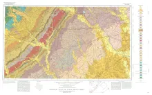
Geologic map that depicts the surface geology of Colorado, Lavaca, and Gonzales Counties, and parts of Hays, Caldwell, Bastrop, Fayette, Austin, Waller, Fort Bend, Wharton, Matagorda, Jackson, Victoria, De Witt, Karnes, Wilson, and Guadalupe Counties, Texas. The 7-page booklet indicates geologic formations, abbreviations, and ages.
Lignite or low-rank coal is a major energy resource in Texas, providing energy since 1850. Prior to 1930, and the advent of abundant natural gas and oil, lignite was a major energy source. Today it is again assuming a substantial role in energy generation with the operation or scheduled construction by 1980 of lignite-fueled, steam-electric plants (up to 1500-megawatt capacities) near Alcoa, Fairfield, Athens, Mt. Pleasant, and Tatum. Future utilization of Texas lignite is likely in the production of synthetic gases, liquid fuels, and chemical feed stocks.
Geothermal energy is rapidly becoming recognized, both in the United States and abroad, as a viable source of energy which can supplement fossil fuels for electric power generation. Exploration and development of geothermal reservoirs is intensifying in the western United States and Mexico, and will continue to expand as petroleum supplies diminish and costs increase. Although geothermal energy is commonly perceived as a new and exotic energy source, it is neither.
The San Angelo Formation is a mid-Permian sandstone and mudstone sequence about 100 feet thick that crops out in North Texas and dips westward into the Midland Basin; it is composed of two superposed members: the basal Duncan Sandstone Member and the overlying Flowerpot Mudstone Member. Depositional systems within the Duncan Member include the Copper Breaks deltaic system in the north, the Old Glory fluvial-deltaic system in the south, and the intermediate, strike-fed Buzzard Peak sand-rich tidal-flat system.