
Over 7,000 miles of lineations have been observed on aerial photographic mosaics of the Texas Coastal Zone. These lineations, in part, represent the surface traces of faults originating in the Tertiary sediments and propagating through the Quaternary sediments. The extrapolation of subsurface faults from specific oil and gas reservoirs are commonly coincident to lineations in those areas. Some extrapolated fault traces weave back and forth across lineations for 10 to 20 miles and then coincide with another lineation and follow it for 20 miles.
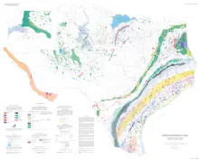
This large-scale map of Texas displays the full range and scope of energy resources in the State. Oil and gas fields are shown according to the age of the producing reservoir. Lignite resources, both near surface and deep basin, are delineated as are the outcrops of bituminous coal-bearinq strata. Sites of old coal mines, uranium mines, potential geothermal resources, and potential oil shale resources are also shown. Resource-distribution systems noted on the map include railroads, principal highways, waterways.
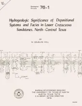
The Lower Cretaceous Hosston and Hensel Sandstones are important sources of ground water in North-Central Texas. Delineation of major depositional systems and their component facies within these formations provides a method for predicting the quantity, movement, and chemical composition of water in the aquifers. The Hosston and Hensel Sandstones were deposited during minor reversals of marine transgression onto the Texas craton by Comanchean (Lower Cretaceous) seas.
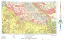
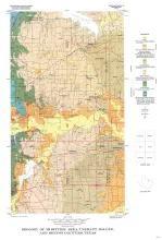
Geologic map that depicts the surface geology of Loving, Crane, and Ward Counties and parts of Ector, Midland, Upton, Pecos, Reeves, Crockett, and Winkler Counties, Texas. The 5-page booklet indicates geologic formations, abbreviations, and ages.