The Gas Research Institute, U.S. Department of Energy, and the State of Texas cooperated in joint-venture research to evaluate the infield reserve growth potential of mature gas fields containing conventional reservoirs. Whole cores from fluvial (middle Frio) and deltaic (Vicksburg and Wilcox) reservoirs of the Gulf Coast Basin were compared to diverse types of well logs, analyzed for diagenetic alteration, and calibrated to porosity, permeability, and petrophysical parameters.
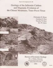
The 37-Ma-old Infiernito caldera of the northern Chinati Mountains is a major eruptive center of the mid-Tertiary volcanic field of Trans-Pecos Texas. Volcanism in the Chinati Mountains began with eruption of a sequence of rhyolitic to trachytic lavas, the precollapse lavas. These lavas progress stratigraphically upward from aphyric or sparsely porphyritic rhyolite to abundantly porphyritic trachyte; they appear to represent tapping of a compositionally zoned magma chamber.
A waterflood was begun in 1985 in Taylor-Link West San Andres unit (10 million barrels cumulative production) on the south margin of the Central Basin Platform to capture a remaining mobile oil target estimated at 20 million barrels. From the onset of injection, oil-water ratios of 0.01 or less were recorded, which indicated that a simple, layered reservoir model was inadequate to describe observed performance.
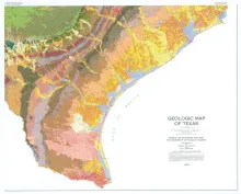
This large, 4-sheet geologic map displays more than 350 lithostratigraphic units ranging in age from Precambrian to Quaternary. In addition to the bedrock and unconsolidated surficial units, the map shows many major cultural features, such as county boundaries, cities, state and federal highways, and railroad lines. Each sheet measures 3.6 x 4.3 ft; if assembled together finished size is 7.2 x 8.6 ft. Sold as a set.