
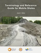
Despite the increasing interest in shale tectonics, general studies on this topic remain scarce, with most existing research focusing primarily on mud volcanoes. Many aspects of the geological processes, geophysical characteristics, and seismic imaging of these structures still need to be better established, especially when compared to the well-documented and thoroughly understood salt systems.
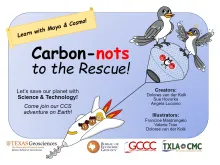
The Carbon-nots to the Rescue comic book was initially designed as supplemental material to help middle school science teachers explain new concepts within revised state educational standards for Texas students, known as Texas Essential Knowledge and Skills (TEKS). This comic book colorfully illustrates the importance of science (e.g., elements, molecules, geology, pore space) and outlines how innovative technology in Texas, known as carbon capture and storage (CCS), will help decrease atmospheric greenhouse gases.

Palynological analysis of four onshore wells (Edmond Olinick No 1, Jerome Olinick No 16, Lawrence Keseling No 1, Moczygemba VT No 11) in the Paleocene Lower Wilcox Group of Texas in the United States has yielded abundant and diverse palynomorph taxa from Paleocene shallow marine deltaic paleoenvironments. Information about the morphologies, biological affinities, paleoecologies, and stratigraphic ranges of the observed palynomorphs is presented here with the goal of serving as a practical reference guide for the palynology of the Lower Wilcox Group.
In 1909, the Bureau of Economic Geology (Bureau) was created with the mission to increase the understanding of geology and geological resources, and stimulate the economy in Texas. In 2024, the Bureau has two roles: one as a research organization that conducts translational and applied research on geosciences that have global reach and impact, and one as the State Geological Survey of Texas continuing its Texas-focused mission.