Texas Gulf Coast Publications
| Title | Publication Year Sort ascending | Abstract | Author | Series | Publisher | |
|---|---|---|---|---|---|---|
|
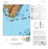
Geologic map of the Port Ingleside quadrangle, Texas Gulf coast | 2025 | Paine, J.G., Caudle, T.L., Morris, J.N., Grunau, B.A. | Open-File Map | Bureau of Economic Geology | |
|
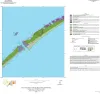
Geologic map of the Decros Point quadrangle, Texas Gulf Of Mexico Coast | 2024 | Aerial imagery used in this study included 0.6- and 1.0-m pixel, natural color, National Agriculture Imagery Program digital imagery photographed in 2020 and 2022. |
Morris, J.N., Paine, J.G. | Open-File Map | Bureau of Economic Geology |
|
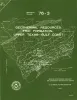
Geothermal resources, Frio Formation, upper Texas Gulf coast | 1976 | The objective of this study is to identify major sand trends, which, along with subsurface temperatures and pressures, aid in evaluating the potential of producing geothermal energy from the Frio Formation, Upper Texas Gulf Coast. |
Bebout, D.G., Loucks, R.G., Bosch, S.C., Dorfman, M.H., Jones, R.A., Luttrell, P.E., Potter, J.D., Sanders, G.B. | Geological Circular | Bureau of Economic Geology |