|
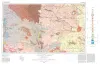
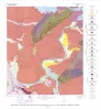
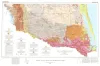
Geologic Atlas of Texas, Hobbs sheet |
Barnes, V.E., Eifler, G.K., Reeves, C.C., Kottlowski, F.E., Norman, D.M., Sherrod, C.H., Hansen, J.J. |
1976 |
Geologic Atlas of Texas |
|
Shoreline changes on Matagorda Island and San Jose Island (Pass Cavallo to Aransas Pass) -- an analysis of historical changes of the Texas Gulf shoreline |
Morton, R.A., Pieper, M.J. |
1976 |
Geological Circular |
|
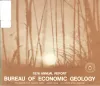
Annual Report of the Bureau of Economic Geology 1976 |
University of Texas at Austin, Bureau of Economic Geology |
1976 |
Annual Reports |
|
Regional Tertiary cross sections -- Texas Gulf coast |
Bebout, D.G., Luttrell, P.E., Seo, J.H. |
1976 |
Geological Circular |
|
Geology of the Kingsland Quadrangle, Llano and Burnet Counties, Texas |
Barnes, V.E. |
1976 |
Geologic Quadrangle Map |
|
GCAGS Transactions Volume 26 (1976) Shreveport |
|
1976 |
Gulf Coast Association of Geological Societies |
|
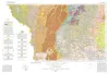
Geologic Atlas of Texas, Laredo sheet |
Barnes, V.E., Mobil Oil Co., Shell Oil Co., Humble Oil and Refining Co., Owens, Frith, Brewton, J.L., Tobin, Edward, Martin, R.G., Maxson, M.J., Wyeth, J.C., Knupke, J.A., Buck, C.E., Dubois, Deane |
1976 |
Geologic Atlas of Texas |
|
Shoreline changes on Matagorda Peninsula (Brown Cedar Cut to Pass Cavallo) -- an analysis of historical changes of the Texas Gulf shoreline |
Morton, R.A., Pieper, M.J., McGowen, J.H. |
1976 |
Geological Circular |
|
Geology of Midcities Area, Tarrant, Dallas, and Denton Counties, Texas |
Hendricks, Leo, Sampson, H.H. |
1976 |
Geologic Quadrangle Map |
|
Geothermal Resources of the Texas Gulf Coast: Environmental Concerns Arising from the Production and Disposal of Geothermal Waters |
Gustavson, T.C., Kreitler, C.W. |
1976 |
Geological Circular |
|
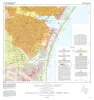
Environmental geologic Atlas of the Texas coastal zone -- Corpus Christi area |
Brown, L.F., Jr., Brewton, J.L., McGowen, J.H., Evans, T.J., Fisher, W.L., Groat, C.G. |
1976 |
Environmental Geologic Atlas of the Texas Coastal Zone |
|
The Mineral Industry of Texas in 1976 |
Hawkins, M.E., Evans, T.J. |
1976 |
Mineral Resource Circular |
|
Geologic Atlas of Texas, McAllen-Brownsville sheet |
Barnes, V.E., Humble Oil and Refining Co., Shell Oil Co., Mobil Oil Co., Owens, Frith, Brewton, J.L., Aronow, Saul, Martin, R.G., Maxson, M.J., Wyeth, J.C., Knupke, J.A., Buck, C.E., Dubois, Deane |
1976 |
Geologic Atlas of Texas |
|
Guide to points of geologic interest in Austin |
Trippet, A.R., Garner, L.E. |
1976 |
Guidebook |
|
Shoreline changes in the vicinity of Brazos River delta (San Luis Pass to Brown Cedar Cut) -- an analysis of historical changes of the Texas Gulf shoreline |
Morton, R.A., Pieper, M.J. |
1975 |
Geological Circular |

|
The Fossil Horses of the Texas Gulf Coastal Plain: A Revision |
|
1975 |
Texas Memorial Museum |

|
Flood hazards along the Balcones escarpment in central Texas -- alternative approaches to their recognition, mapping, and management |
Baker, V.R. |
1975 |
Geological Circular |
|
Geologic Atlas of Texas, Corpus Christi sheet |
Barnes, V.E., Aronow, Saul, Humble Oil and Refining Co., Martin, R.G., Maxson, M.J., Wyeth, J.C., Knupke, J.A., Buck, C.E., Dubois, Deane |
1975 |
Geologic Atlas of Texas |
|
Shoreline changes between Sabine Pass and Bolivar Roads -- an analysis of historical changes of the Texas Gulf shoreline |
Morton, R.A. |
1975 |
Geological Circular |
|
Preliminary Study of Biologic Assemblages of East Texas Lignite Belt |
Holm, M. |
1975 |
Research Note |