Publication Details
Geolocation:
Get the Publication
$11.50
Abstract/Description:
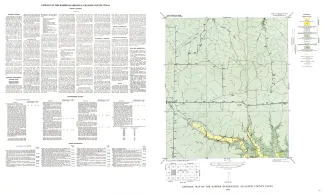
Harper quadrangle is in the Edwards Plateau province south of the Llano region. The plateau surface within the quadrangle is dissected by the Pedernales River and its tributaries in the southern part, and by Threadgill and Edwards Creeks in the northern part.
The geology of the Harper quadrangle is shown on a planimetric map, and the only topographic map available is the reconnaissance 30-minute Kerrville quadrangle. Elevations ranging between 1,891 and 2,226 feet were determined during traversing for control, but only the highest point was reached. The lowest point is somewhere in the southeastern part of the quadrangle and is estimated to be at an elevation of about 1,800 feet, giving about 425 feet of relief for the quadrangle.
About two-thirds of the quadrangle is directly drained by Pedernales River and its branches. The northern third of the quadrangle is in the Llano River drainage basin and is drained by Edwards Creek, Maverick Spring Branch, and the headwaters of Threadgill Creek, which reach Llano River by way of Threadgill Creek and Beaver Creek.
The Harper quadrangle is on the south side of the Llano uplift, and Cretaceous rocks crop out in all of the quadrangle. Rocks of Cambrian and Ordovician age are not far beneath the more deeply incised streams. The Cretaceous rocks are essentially horizontal and may dip 2 or 3 feet per mile to the northwest.
Broader discussions of the stratigraphic, structural, economic, and geophysical problems of the region are given in references cited below. This publication on the Harper quadrangle is one of a series of similar publications, an index to which is shown on the opposite page. The reader is referred to the index map to locate other quadrangles mentioned in the present text.