Harper Quadrangle Publications
| Title | Publication Year Sort ascending | Abstract | Author | Series | Publisher | |
|---|---|---|---|---|---|---|
|
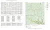
Geologic map of the Harper quadrangle, Gillespie County, Texas | 1954 | Harper quadrangle is in the Edwards Plateau province south of the Llano region. The plateau surface within the quadrangle is dissected by the Pedernales River and its tributaries in the southern part, and by Threadgill and Edwards Creeks in the northern part. |
Barnes, V.E. | Geologic Quadrangle Map | Bureau of Economic Geology |