Publications in Val Verde
| Title | Publication Year Sort ascending | Abstract | Author | Series | Publisher | |
|---|---|---|---|---|---|---|

|
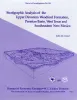
Electrical Imaging Catalog: Microresistivity Images and Core Photos from Fractured, Karsted, and Brecciated Carbonates | 1997 | Electrical images in boreholes are becoming increasingly important in interpreting the rock record. |
Hammes, Ursula | Geological Circular | Bureau of Economic Geology |

|
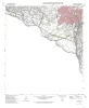
Geologic map of the Del Rio NW Quadrangle, Texas | 1997 | Collins, E.W. | Open-File Map | Bureau of Economic Geology | |
|
Geologic map of the Del Rio SW Quadrangle, Texas | 1997 | Collins, E.W. | Open-File Map | Bureau of Economic Geology | |

|
Canyon sandstones -- a geologically complex natural gas play in slope and basin facies, Val Verde basin, southwest Texas | 1995 | Canyon sandstones form a prolific low-permeability gas play in the Val Verde Basin of southwest Texas. Exploration and development activity is at a high level, but little published information on Canyon geology is available. |
Hamlin, H.S., Clift, S.J., Dutton, S.P., Hentz, T.F., Laubach, S.E. | Report of Investigations | Bureau of Economic Geology |
|
Stratigraphic analysis of the Upper Devonian Woodford Formation, Permian Basin, West Texas and southeastern New Mexico | 1991 | The Upper Devonian Woodford Formation is an organic-rich petroleum source rock that extends throughout West Texas and southeastern New Mexico and currently is generating oil or gas in the subsurface. |
Comer, J.B. | Report of Investigations | Bureau of Economic Geology |

|
Geology of the Carta Valley fault zone area: Edwards, Kinney, and Val Verde Counties, Texas | 1982 | Webster, R.E. | Geologic Quadrangle Map | Bureau of Economic Geology | |

|
Geologic Atlas of Texas, Sonora sheet | 1981 | Geologic map that depicts the surface geology of Sutton County and parts of Terrell, Crockett, Val Verde, Edwards, Kimble, Menard, Schleicher, and Pecos Counties. |
Barnes, V.E., McKalips, D.G., Cities Service Petroleum Co., Geophoto Services Inc., Stump, R.W., Brown, J.B., Pearson, B.T., Volkmann, R.G. | Geologic Atlas of Texas | Bureau of Economic Geology |

|
Geologic Atlas of Texas, Del Rio sheet | 1977 | Geologic map that depicts surface geology of Kinney County and parts of Terrell, Val Verde, Edwards, Real, Uvalde, and Maverick Counties, Texas. |
Barnes, V.E., Waechter, N.B., Pinkley, G.R., Martin, R.G., Wyeth, J.C., Knupke, J.A., Sulik, J.F., Ellis, W.G. | Geologic Atlas of Texas | Bureau of Economic Geology |

|
Mineral resources of south Texas: region served through the port of Corpus Christi | 1962 | This report is a compilation of all available data on mineral resources (exclusive of oil and gas) in 39 south Texas counties. Information from published and unpublished sources was checked and supplemented by field investigations. |
Maxwell, R.A. | Report of Investigations | Bureau of Economic Geology |
|
The Occurrence of Manganese on the Ingram-Howe Ranch, with Notes on Other Areas along Pecos River, Val Verde County, Texas | 1942 | This report deals essentially with the occurrence of manganese on the Ingram-Howe ranch, 3 miles north of Shumla, where several test pits were dug and the manganese sampled for analyses. |
Warren, L.E. | Mineral Resource Survey Circulars |