Publications in Refugio
Title | Publication Year Sort ascending | Abstract | Author | Series | Publisher | |
---|---|---|---|---|---|---|
![]() |
Geologic map of the Rincon Bend quadrangle, Aransas River and Copano Bay area, Texas Gulf of Mexico coast | 2015 | Paine, J.G., Collins, E.W., Costard, L. | Open-File Map | Bureau of Economic Geology | |
![]() |
Geologic map of the Woodsboro quadrangle: Aransas and Mission Rivers, and Copano Bay area, Texas Gulf of Mexico Coast | 2015 | Paine, J.G., Collins, E.W., Costard, L. | Open-File Map | Bureau of Economic Geology | |
![]() |
Geologic map of the Bayside quadrangle: Aransas Delta and Copano Bay Area, Texas Gulf of Mexico Coast | 2014 | Paine, J.G., Collins, E.W. | Open-File Map | Bureau of Economic Geology | |
![]() |
Geologic map of the Mission Bay quadrangle: Mission Delta and Copano Bay area, Texas Gulf of Mexico Coast | 2014 | Paine, J.G., Collins, E.W. | Open-File Map | Bureau of Economic Geology | |
![]() |
Geologic map of the Guadalupe delta, Texas Gulf of Mexico Coast: Sheet 1-Austwell quadrangle | 2013 | Paine, J.G., Collins, E.W. | Open-File Map | Bureau of Economic Geology | |
![]() |
Geologic map of the Guadalupe delta, Texas Gulf of Mexico Coast: Sheet 2-Bloomington SW quadrangle | 2013 | Collins, E.W., Paine, J.G. | Open-File Map | Bureau of Economic Geology | |
![]() |
Geologic map of the Guadalupe delta, Texas Gulf of Mexico Coast: Sheet 5-Tivoli quadrangle | 2013 | Collins, E.W., Paine, J.G. | Open-File Map | Bureau of Economic Geology | |
![]() |
Historical shoreline changes in Copano, Aransas, and Redfish Bays, Texas Gulf coast | 1993 | 
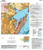
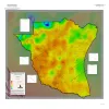
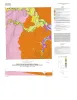
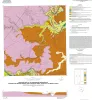
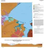
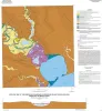
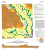
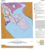
Shorelines bordering the bays of Texas are generally not as dynamic as those along the Gulf of Mexico. Nevertheless, the predominantly erosional movement of these bay shorelines translates to large losses of wetlands, arable uplands, and recreational and residential property. |
Paine, J.G., Morton, R.A. | Geological Circular | Bureau of Economic Geology |
![]() |
Core and Log Analyses of Depositional Systems and Reservoir Properties ... in Frio, Vicksburg, and Wilcox Sandstones | 1992 | The Gas Research Institute, U.S. Department of Energy, and the State of Texas cooperated in joint-venture research to evaluate the infield reserve growth potential of mature gas fields containing conventional reservoirs. |
Levey, R.A., Grigsby, J.D. | Geological Circular | Bureau of Economic Geology |
![]() |
Shoreline and vegetation-line movement, Texas Gulf coast, 1974 to 1982 | 1989 | The purposes of this study were (1) to quantify recent (1974 to 1982) movement of Texas shorelines and vegetation lines by analysis of aerial photographs; (2) to place this movement in historical (pre-1974) context; and (3) to examine the influence of environmental variables such as storms, sea l |
Paine, J.G., Morton, R.A. | Geological Circular | Bureau of Economic Geology |