Publications in Reeves
| Title | Publication Year Sort ascending | Abstract | Author | Series | Publisher | |
|---|---|---|---|---|---|---|
|
Annotated bibliography of mineral deposits in Trans-Pecos Texas | 1983 | Price, J.G., Henry, C.D., Standen, A.R. | Mineral Resource Circular | Bureau of Economic Geology | |

|
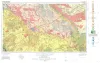
Geologic Atlas of Texas, Fort Stockton sheet (revised 1994) | 1982 | Geologic map that depicts the surface geology of parts of Jeff Davis, Reeves, Pecos, Terrell, Brewster, and Presidio Counties, Texas. The 9-page booklet indicates geologic formations, abbreviations, and ages. |
Barnes, V.E., Humboldt Oil and Refining Co., Mobil Oil Co., Geophoto Services Inc., Cities Service Petroleum Co., Anderson, J.E., Brown, J.B., Gries, J.C. | Geologic Atlas of Texas | Bureau of Economic Geology |
|
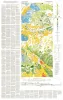
Geologic Atlas of Texas, Pecos sheet | 1976 | Geologic map that depicts the surface geology of Loving, Crane, and Ward Counties and parts of Ector, Midland, Upton, Pecos, Reeves, Crockett, and Winkler Counties, Texas. The 5-page booklet indicates geologic formations, abbreviations, and ages. |
Barnes, V.E., Eifler, G.K., Shell Oil Co., Cities Service Petroleum Co., Brown, J.B. | Geologic Atlas of Texas | Bureau of Economic Geology |
| |
Geologic Atlas of Texas, Van Horn-El Paso sheet (revised 1983) | 1968 | Geologic map that depicts the surface geology of El Paso County and parts of Hudspeth. Jeff Davis, and Culberson Counties, Texas. The 12-page booklet indicates geologic formations, abbreviations, and ages. Published in honor of E. |
Barnes, V.E., Shell Oil Co., Cities Service Petroleum Co., Dietrich, J.W., Owen, D.E., Shelby, C.A., Macon, J.W., Bridges, L.W. | Geologic Atlas of Texas | Bureau of Economic Geology |

|
Pleistocene molluscan faunas and physiographic history of Pecos Valley in Texas | 1962 | Studies of physiographic relations and of fossil molluscan faunas made in the Pecos River valley region (Val Verde County to the Texas�New Mexico border) reveal extensive, well-pedimented surfaces southwest of the river extending from the Davis Mountains to near the present channel. |
Leonard, A.B., Frye, J.C. | Report of Investigations | Bureau of Economic Geology |
|
Geology of Eastern Half of Kent Quadrangle, Culberson, Reeves, and Jeff Davis Counties, Texas | 1962 | Study of Permian, Cretaceous, and Cenozoic rocks in the 30 Kent quad- rangle is important to an understanding of the geology of Trans-Pecos Texas. Most of the Cretaceoua rock units of central Texas lose their lithostratigraphic identity when traced into west Texas. |
Brand, J.P., DeFord, R.K. | Geologic Quadrangle Map | Bureau of Economic Geology |
|
Comanchean Stratigraphy of Kent Quadrangle, Trans-Pecos Texas | 1958 | At the northern end of the Coahuila platform, the thinned Comanchean sequence consists of the newly named Sixshooter group of carbonate formations underlain by the newly named Yearwood formation. |
Brand, J.P., DeFord, R.K. | Report of Investigations | Bureau of Economic Geology |

|
Occurrence of Oil and Gas in West Texas | 1957 | Herald, F.A. | UT Publication | ||
|
Geology of the Barrilla Mountains, Texas | 1950 | The Barrilla Mountains, in the northeastern part of the Davis Mountains of Trans-Pecos Texas, are composed of Tertiary volcanic materials. Five tuffs and five lava flows, 1500 feet thick occurring throughout the mountains, persist in thickness and lithologic characteristics. |
Eifler, G.K. | Report of Investigations | Bureau of Economic Geology |
|
The Rustler Springs sulphur deposits as a source of fertilizer | 1946 | The occurrence of sulphur in the vicinity of Rustler Springs in northeastern Culberson County, Texas, has been known since 1854 when, according to Phillips (1902, pp. 13, 71), the mineral was recognized by William P. Blake, a geologist attached to a U.S. |
Evans, G.L. | Report of Investigations | Bureau of Economic Geology |