Publications in Randall
| Title | Publication Year Sort ascending | Abstract | Author | Series | Publisher | |
|---|---|---|---|---|---|---|
|
Organic geochemistry of the Pennsylvanian and Lower Permian, Palo Duro basin, Texas | 1986 | Cores from deep stratigraphic test wells provide an excellent basis for determination of source-rock quality and thermal maturity of potential hydrocarbon source rocks in the Palo Duro Basin. Total organic carbon (TOC) content in Pennsylvanian and Wolfcampian rocks is highest in basinal shales. |
Dutton, S.P. | Geological Circular | Bureau of Economic Geology |
|
Bouguer gravity Atlas of Texas, Clovis sheet | 1985 | This folded transparent map is at the same scale as its corresponding Geologic Atlas of Texas (GAT) sheet and can be superimposed on it to compare gravity information with surface geology. |
Keller, G.R., Aiken, C.L.V. | Bouguer Gravity Atlas of Texas | Bureau of Economic Geology |
|
Investigation of underpressuring in the deep-basin brine aquifer, Palo Duro basin, Texas | 1985 | Although plots of pressure versus depth are useful for understanding the hydrodynamics of ground-water systems, they can be difficult to interpret. |
Orr, E.D., Kreitler, C.W., Senger, R.K. | Geological Circular | Bureau of Economic Geology |
|
Amount and nature of occluded water in bedded salt, Palo Duro basin, Texas | 1985 | Bedded salt of the Permian San Andres Formation, Palo Duro Basin, Texas, is under consideration for the isolation of high-level nuclear waste. |
Fisher, R.S. | Geological Circular | Bureau of Economic Geology |
|
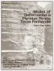
Styles of deformation in Permian strata, Texas panhandle | 1984 | Permian strata in the Texas Panhandle exhibit a variety of deformation styles that are attributed to tectonic stresses as well as to collapse caused by evaporite dissolution. At Caprock Canyons State Park, deformation structures above salt dissolution zones include veins, faults, and folds. |
Collins, E.W. | Geological Circular | Bureau of Economic Geology |
|
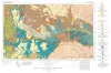
Geologic Atlas of Texas, Tucumcari sheet | 1983 | Geologic map that depicts the surface geology of Oldham County and parts of Hartley, Deaf Smith, Moore, Potter, and Randall Counties. |
Barnes, V.E., Eifler, G.K., Trauger, F.D., Spiegel, Z., Hawley, J.W., Dillon, R.L., Kottlowski, F.E., Hood, C. | Geologic Atlas of Texas | Bureau of Economic Geology |

|
Deep brine aquifers in the Palo Duro basin: regional flow and geochemical constraints | 1983 | Geologic characterization of evaporite deposits as potential host rocks for burial of radioactive waste must include hydrogeologic investigations at both local and regional scales. |
Bassett, R.L., Bentley, M.E., Duncan, E.A. | Report of Investigations | Bureau of Economic Geology |

|
Coastal evaporite and tidal-flat sediments of the upper Clear Fork and Glorieta Formations, Texas panhandle | 1982 | Red beds, evaporites, and carbonates of the upper Clear Fork and Glorieta Formations (Permian) of the Texas Panhandle form an association of facies deposited in nearshore and supratidal environments along an arid coastline. |
Presley, M.W., McGillis, K.A., Mikan, F.M., Gray, C.A. | Report of Investigations | Bureau of Economic Geology |

|
San Andreas carbonates in the Texas panhandle: sedimentation and diagenesis associated with magnesium-calcium-chloride brines | 1982 | The San Andres evaporitic sequence in the Palo Duro Basin comprises several thick carbonate units in its lower part and many thin units in its upperpart. To the south, across the Northern Shelf of the Midland Basin, evaporites pinch out and carbonates predominate. |
Bein, Amos, Land, L.S. | Report of Investigations | Bureau of Economic Geology |
|
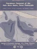
Petroleum potential of the Palo Duro basin, Texas panhandle | 1982 | The Palo Duro Basin seemingly has all the elements necessary for hydrocarbon generation and accumulation: reservoirs, traps, source rocks, and sufficient thermal maturity. Porous facies in pre-Pennsylvanian, Pennsylvanian, and Permian strata are potential hydrocarbon reservoirs. |
Dutton, S.P., Goldstein, A.G., Ruppel, S.C. | Report of Investigations | Bureau of Economic Geology |