Publications in Randall
| Title | Publication Year Sort ascending | Abstract | Author | Series | Publisher | |
|---|---|---|---|---|---|---|
|
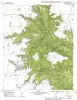
Geologic map of the Fortress Cliff Quadrangle, Texas | 1998 | Raney, J.A., Collins, E.W. | Open-File Map | Bureau of Economic Geology | |
|
Spatial variability in unsaturated flow beneath playa and adjacent interplaya settings and implications for contaminant transport, southern High Plains, Texas | 1997 | Analysis of spatial variability in unsaturated flow is critical to evaluating contaminant transport in areas of focused or preferential flow. This study examined spatial variability at a variety of scales from focused flow through playas to preferential flow in macropores. |
Scanlon, B.R., Goldsmith, R.S., Mullican, W.F. | Report of Investigations | Bureau of Economic Geology |
|
Playas and recharge of the Ogallala aquifer on the southern High Plains of Texas -- an examination using numerical techniques | 1997 | This study used a numerical model to examine the playa-focused recharge theory by comparing it with the spatially uniform approach and with a zonal approach. |
Mullican, W.F., Johns, N.D., Fryar, A.E. | Report of Investigations | Bureau of Economic Geology |
|
Water-level controls on halite sedimentation: Permian cyclic evaporites of the Palo Duro basin | 1994 | Extensively cored cyclic evaporites of the San Andres Formation (Guadalupian) of the Palo Duro Basin, Texas Panhandle, provided fundamental information for interpreting evaporite depositional processes. |
Hovorka, S.D. | Report of Investigations | Bureau of Economic Geology |
|
Geologic Significance of Remotely Sensed Physiographic Features of the Texas Panhandle and Adjacent Regions | 1990 | Remotely sensed features such as linear drainages, escarpments, ridges, and aligned playas have been identified on Landsat imagery (scale 1:250,000) of the Texas Panhandle and adjacent regions to allow comparison of these features with detailed regional and site-specific geologic data. |
Collins, E.W. | Geological Circular | Bureau of Economic Geology |
|
Tertiary and Quaternary stratigraphy and vertebrate paleontology of parts of northwestern Texas and eastern New Mexico | 1990 | This field guide summarizes recent interpretations of the upper Cenozoic stratigraphy of parts of the Southern High Plains and Rolling Plains in northwestern Texas and eastern New Mexico. |
Gustavson, T.C., Holliday, V.T., Osterkamp, W.R., Schultz, G.E., Winkler, D.A. | Guidebook | Bureau of Economic Geology |
|
Lithogenetic stratigraphy of the Triassic Dockum Formation, Palo Duro basin, Texas | 1989 | Four clastic depositional sequences compose the lower part of the Triassic Dockum Formation in the Palo Duro Basin. |
Johns, D.A. | Report of Investigations | Bureau of Economic Geology |
|
Tectonic structures of the Palo Duro basin, Texas panhandle | 1989 | The Palo Duro Basin is a broad structural low in the southern Texas Panhandle that formed as a result of nearly continuous Pennsylvanian and Permian subsidence. True complexity of this basin is unknown because of the sparsity of structural information. |
Budnik, R.T. | Report of Investigations | Bureau of Economic Geology |
|
Stratigraphy and influence of effective porosity on ground-water flow in the Wolfcamp brine aquifer, Palo Duro basin, Texas panhandle | 1988 | In the Palo Duro Basin, the Wolfcampian Series (lower Permian) overlies Pennsylvanian (primarily Virgilian) strata and underlies the Wichita Group (Leonardian). |
Conti, R.D., Herron, M.J., Senger, R.K., Wirojanagud, Prakob | Report of Investigations | Bureau of Economic Geology |

|
Hydrogeology and hydrochemistry of the Ogallala aquifer, southern High Plains, Texas panhandle and eastern New Mexico | 1988 | The Ogallala aquifer, which underlies the Southern High Plains, consists of the saturated sediments of the Neogene Ogallala Formation. The aquifer is the main source of water for the High Plains of Texas and New Mexico and is being severely depleted by extensive pumpage for irrigation. |
Nativ, Ronit | Report of Investigations | Bureau of Economic Geology |