Publications in Nueces
| Title | Publication Year Sort ascending | Abstract | Author | Series | Publisher | |
|---|---|---|---|---|---|---|
|
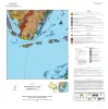
Geologic map of the Port Ingleside quadrangle, Texas Gulf coast | 2025 | Paine, J.G., Caudle, T.L., Morris, J.N., Grunau, B.A. | Open-File Map | Bureau of Economic Geology | |
|
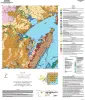
Geologic map of the Copano Bay area, Texas Gulf Coast | 2025 | Paine, J.G., Collins, E.W., Costard, L., Grunau, B.A., Morris, J.N., Caudle, T.L. | Open-File Map | Bureau of Economic Geology | |
|
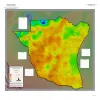
Geothermal Resources, South Texas | 2024 | A series of two 1:500,000 scale maps showing the Geothermal resources of South Texas. |
Andrews, J.R. | Open-File Map | Bureau of Economic Geology |
|
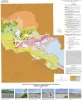
Geologic map of the Nueces Delta-Annaville and Odem quadrangles, Texas Gulf Coast | 2012 | Paine, J.G., Collins, E.W. | Open-File Map | Bureau of Economic Geology | |
|
Reservoir Geology, Structural Architecture, and Sequence Stratigraphy of a Growth-Faulted Subbasin: Oligocene Lower Frio Formation, Red Fish Bay Area, South Texas Gulf Coast | 2007 | An integrated study using 3D seismic, wireline logs, and core analyses was conducted to establish new strategies for exploring compartmentalized, lowstand, prograding deltaic systems. |
Hammes, Ursula, Loucks, R.G., Brown, L.F., Jr., Treviño, R.H., Montoya, Patricia, Remington, R.L. | Report of Investigations | Bureau of Economic Geology |
|
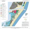
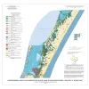
Geo-Environmental map of Northern Mustang Island, Port Aransas quadrangle, Texas Gulf of Mexico Coast | 2006 | Tremblay, T.A., Gibeaut, J.C., Waldinger, R.L., White, W.A., Collins, E.W. | Open-File Map | Bureau of Economic Geology | |
|
Geo-Environmental map of Southern Mustang Island, Crane Islands NW quadrangle, Texas Gulf of Mexico Coast | 2006 | Tremblay, T.A., Gibeaut, J.C., Waldinger, R.L., White, W.A., Collins, E.W. | Open-File Map | Bureau of Economic Geology | |
|
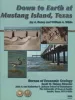
Down to Earth at Mustang Island, Texas | 2002 | Beautifully illustrated by more than 100 photos and diagrams, this nontechnical guide surveys the geologic evolution of Mustang Island and the relationship between physical setting and biologic environments along the Texas coast. |
Raney, J.A., White, W.A. | Down To Earth | Bureau of Economic Geology |
|
Resource optimization through geological and petrophysical characterization of downdip Frio shoreface/shelf sandstone reservoirs: Red Fish Bay field, south Texas | 1998 | Located in Nueces County, 5 mi southeast of Aransas Pass in Corpus Christi Bay, Red Fish Bay field has yielded more than 19 MMbbl of liquid hydrocarbons and 103 Bcf of gas from more than 50 stacked Frio Sandstone reservoirs since field discovery in 1950. |
Barnaby, R.J., Ramamoorthy, R., Holtz, M.H. | Report of Investigations | Bureau of Economic Geology |
|
Identification and assessment of remaining oil resources in the Frio fluvial-deltaic sandstone play, south Texas | 1995 | The Frio Fluvial-Deltaic Sandstone (Vicksburg Fault Zone) play of South Texas has produced nearly 1 billion barrels (Bbbl) of oil since field development began in the 1940's. |
Holtz, M.H., McRae, L.E. | Report of Investigations | Bureau of Economic Geology |