Publications in Llano
| Title | Publication Year Sort ascending | Abstract | Author | Series | Publisher | |
|---|---|---|---|---|---|---|
|
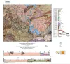
Geologic map of a Portion of the Southeastern Llano Uplift, Burnet, Llano, and Blanco Counties Texas | 2023 | Helper, M.A., Hunt, B.B., Barnes, V.E. | Open-File Map | Bureau of Economic Geology | |
|
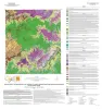
Geologic map of the Pedernales Falls, Johnson City, Howell Mountain, and Round Mountain quadrangles, Blanco County, Texas | 2021 | Hunt, B.B., Woodruff, C.M., Jr., Barnes, V.E. | Open-File Map | Bureau of Economic Geology | |
|
Geologic Map of the Pontotoc Quadrangle, Texas | 2017 | Elliott, Brent A. | Open-File Map | Bureau of Economic Geology | |
|
Petrography and diagenesis of a half-billion-year-old cratonic sandstone (Hickory), Llano region, Texas | 2002 | We studied the Hickory Sandstone Member of the Riley Formation, Central Texas, to assess the diagenetic history of a cratonic sandstone, which, in spite of its great age, remains porous and permeable where it has not been buried more than 1 km. |
McBride, E.F., Abdel-Wahab, A.A., Milliken, K.L. | Report of Investigations | Bureau of Economic Geology |
|
Pavement Deflection and Seismic Refraction for Determining Bedrock Type, Depth, and Physical Properties beneath Roads | 2000 | We examined the relationship between three data types--geologic maps, measurements of pavement deflection under load, and seismic refraction data-- from diverse geologic settings in Texas to determine (1) whether geologic maps and seismic refraction data might be used to interpret deflections and |
Paine, J.G., Murphy, M.R. | Report of Investigations | Bureau of Economic Geology |
|
Geology and Historical Mining, Llano Uplift Region, Central Texas | 2000 | Caran, S.C., Helper, M.A., Kyle, J.R. | Austin Geological Society | Austin Geological Society | |
|
The dimension stone industry of Texas | 1992 | Garner, L.E. | Mineral Resource Circular | Bureau of Economic Geology | |
|
Geology of the Marble Falls quadrangle, Burnet and Llano Counties, Texas. | 1982 | Barnes, V.E. | Geologic Quadrangle Map | Bureau of Economic Geology | |
|
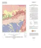
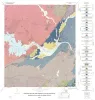
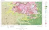
Geologic Atlas of Texas, Llano sheet | 1981 | Geologic map that depicts the surface geology of Mason, Llano, and Gillespie Counties and parts of Menard, Kimble, San Saba, McCulloch, Edwards, Real, Kerr, Kendall, Blanco, Hays, Travis, Williamson, and Burnet Counties, Texas. |
Barnes, V.E., Shell Oil Co., Boyer, R.E., Clabaugh, S.E., Baker, E.T. | Geologic Atlas of Texas | Bureau of Economic Geology |
|
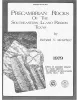
Precambrian rocks of the southeastern Llano region, Texas | 1979 | Precambrian sedimentary rocks and associated mafic and silicic igneous rocks in Central Texas underwent a single episode of regional metamorphism about 1,050 million years (m.y.) ago. |
McGehee, R.V. | Geological Circular | Bureau of Economic Geology |